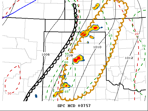
   Mesoscale Discussion 0757
   NWS Storm Prediction Center Norman OK
   0732 PM CDT Wed May 26 2021

   Areas affected...Parts of the Texas/Oklahoma Panhandles and adjacent
   portions of southwestern Kansas/northwestern Oklahoma

   Concerning...Tornado Watch 210...211...

   Valid 270032Z - 270200Z

   The severe weather threat for Tornado Watch 210, 211 continues.

   SUMMARY...Scattered severe storm development, including supercells,
   probably will continue into at least the 9-11 PM CDT time frame.

   DISCUSSION...Intense thunderstorm development along the dryline has
   become most numerous roughly west-northwest of Lubbock, TX into the
   Oklahoma Panhandle, southeast of Liberal, KS.  This probably has
   been the result of somewhat stronger heating to overcome
   lower/mid-level inhibition, in addition to lift supported by weak
   mid-level troughing overspreading the high plains.

   Although inhibition may be in the process of increasing one again,
   as diurnal boundary-layer cooling commences, mixed-layer CAPE
   remains strong, in the presence of strong deep-layer shear aided by
   pronounced veering of lower/mid tropospheric wind fields with
   height.  Coupled with southerly low-level jet strengthening to 40+
   kt, supercell storm development probably will continue into late
   evening, with some upscale growth possible.

   While deep-layer shear is strong, southwesterly ambient deep-layer
   mean flow is still a rather modest 20-30 kt across much of the
   region, so eastward progression of storms likely will remain
   relatively slow.

   ..Kerr.. 05/27/2021

   ...Please see www.spc.noaa.gov for graphic product...

   ATTN...WFO...OUN...DDC...LUB...AMA...

   LAT...LON   33930216 35430180 37749973 37559885 35549985 34220075
               33840166 33930216
|


 @NWSSPC