|
| Mesoscale Discussion 787 |
|
< Previous MD Next MD >
|
|
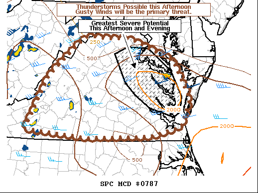
   Mesoscale Discussion 0787
   NWS Storm Prediction Center Norman OK
   0256 PM CDT Fri May 28 2021

   Areas affected...eastern Virginia

   Concerning...Severe potential...Watch unlikely

   Valid 281956Z - 282200Z

   Probability of Watch Issuance...20 percent

   SUMMARY...Ongoing thunderstorms across eastern Virginia will
   continue to pose a threat for gusty winds and hail before crossing
   the Chesapeake. Additional thunderstorms may develop later this
   afternoon farther west posing an additional threat for wind as they
   move east. A watch is currently not expected, but trends will be
   monitored.

   DISCUSSION...A relatively strong coastal front remains draped across
   the Chesapeake Bay area, with easterly flow off the cooler Atlantic
   waters to the north and warm southerly flow to the south. To the
   south of this front, isolated thunderstorms developed earlier this
   afternoon within a zone of strong surface heating (surface
   temperatures greater than 90F) and modest low-level warm-air
   advection. The warm, moist low levels have contributed to
   most-unstable CAPE values around 2000-3000 J/kg across a small
   corridor of eastern Virginia despite weak mid-level lapse rates (on
   the order of 5-6 C/km). Gusty thunderstorm outflow winds will remain
   possible with the stronger updrafts, although a brief tornado
   potential will exist with any thunderstorm moving across the coastal
   front where backed surface winds may support enhanced low-level
   helical flow.

   High-resolution convection permitting models, such as the HRRR and
   experimental WoFS guidance, continue to suggest additional
   thunderstorms may develop across central Virginia this afternoon as
   increased ascent from an approaching mid-level trough encounters the
   aforementioned unstable environment. These thunderstorms will also
   pose a threat for gusty thunderstorm winds as they move east,
   although a brief tornado cannot be ruled out with any thunderstorm
   that interacts with the backed low-level flow in and near the
   aforementioned coastal front.

   At this time thunderstorm coverage is anticipated to remain sparse
   enough to preclude the need for a watch, but conditions will
   continue to be monitored.

   ..Marsh/Hart.. 05/28/2021

   ...Please see www.spc.noaa.gov for graphic product...

   ATTN...WFO...AKQ...LWX...RNK...

   LAT...LON   36788051 38017989 38907887 38877755 38397632 37487584
               36877611 36667693 36627876 36788051
|
|
Top/All Mesoscale Discussions/Forecast Products/Home
|
|


 @NWSSPC