|
| Mesoscale Discussion 815 |
|
< Previous MD Next MD >
|
|
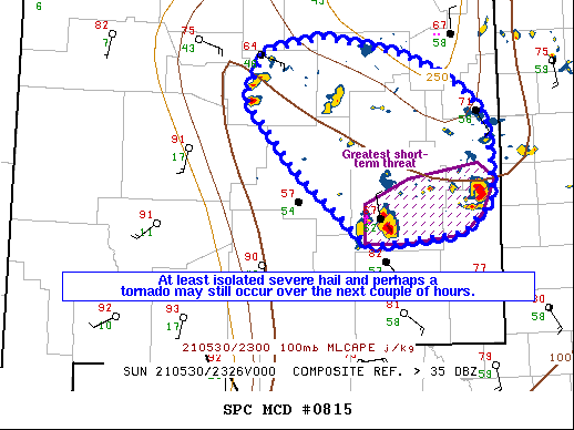
   Mesoscale Discussion 0815
   NWS Storm Prediction Center Norman OK
   0643 PM CDT Sun May 30 2021

   Areas affected...portions of central into southeast New Mexico

   Concerning...Severe Thunderstorm Watch 227...

   Valid 302343Z - 310045Z

   The severe weather threat for Severe Thunderstorm Watch 227
   continues.

   SUMMARY...At least an isolated severe threat may linger across
   portions of central, eastern, and southeastern New Mexico for at
   least a couple more hours. Damaging gusts and large hail are the
   main concerns. The best chance for large hail and perhaps a brief
   tornado will be with the southernmost storms.

   DISCUSSION...Multiple multicellular clusters as well as discrete and
   semi-discrete supercells persist across Severe Thunderstorm Watch
   #227. A few of the stronger storms from Chaves to Lea Counties, NM
   have a history of producing severe hail and a couple of tornadoes
   over the past hour or so. These storms have access to the best
   instability (up to 1000 J/kg MLCAPE), and are expected to have the
   most robust severe threat across eastern NM through this evening.
   Storms farther northwest have been more numerous in nature, with
   gradual convective overturning of the environment noted via 23Z
   mesoanalysis. Still, an instance or two of hail/wind may accompany
   these storms over the next few hours.

   ..Squitieri/Guyer.. 05/30/2021

   ...Please see www.spc.noaa.gov for graphic product...

   ATTN...WFO...MAF...ABQ...

   LAT...LON   33020467 33810558 34540618 35020595 35160521 34970422
               34640354 34350324 33890316 33450318 33130351 33020467
|
|
Top/All Mesoscale Discussions/Forecast Products/Home
|
|


 @NWSSPC