|
| Mesoscale Discussion 820 |
|
< Previous MD Next MD >
|
|
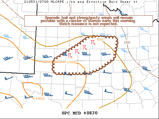
   Mesoscale Discussion 0820
   NWS Storm Prediction Center Norman OK
   0212 AM CDT Mon May 31 2021

   Areas affected...Portions of west into west-central TX

   Concerning...Severe potential...Watch unlikely

   Valid 310712Z - 310945Z

   Probability of Watch Issuance...5 percent

   SUMMARY...Sporadic hail and strong/gusty winds will remain possible
   through the early morning hours with a cluster of storms. Watch
   issuance is not expected.

   DISCUSSION...A small cluster of storms is ongoing as of 0710Z across
   part of west TX. Recent area VWPs show 0-2 km south-southeasterly
   winds around 30-40 kt transporting a low-level moisture fetch into
   this convection. Even with this low-level moisture, the mid-level
   lapse rates are not very steep across this region, which along with
   relatively cool surface temperatures is limiting instability. Even
   so, around 500-1000 J/kg of MLCAPE is present downstream into parts
   of west-central TX. Modestly enhanced mid-level winds preceding an
   upper trough over the Southwest are supporting deep-layer shear of
   40-50 kt per latest mesoanalysis estimates, and occasional embedded
   supercell structures have been noted within the line over the past
   hour or so. Isolated instances of marginally severe hail appear
   possible with any supercell that can be sustained. Otherwise,
   sporadic strong/gusty may occur with convective downdrafts. The weak
   instability should preclude a greater severe threat, and watch
   issuance is not expected.

   ..Gleason/Grams.. 05/31/2021

   ...Please see www.spc.noaa.gov for graphic product...

   ATTN...WFO...SJT...LUB...MAF...

   LAT...LON   32520220 33080116 33400066 33359943 32609960 32230025
               32070075 32060220 32520220
|
|
Top/All Mesoscale Discussions/Forecast Products/Home
|
|


 @NWSSPC