|
| Mesoscale Discussion 845 |
|
< Previous MD Next MD >
|
|
Mesoscale Discussion 0845
NWS Storm Prediction Center Norman OK
0347 PM CDT Thu Jun 03 2021
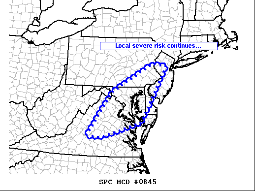
Areas affected...the Mid Atlantic region
Concerning...Severe Thunderstorm Watch 234...
Valid 032047Z - 032215Z
The severe weather threat for Severe Thunderstorm Watch 234
continues.
SUMMARY...Scattered strong/isolated severe storms continue from
southeastern Pennsylvania southwestward into central Virginia, where
locally damaging wind gusts remain the primary risk.
DISCUSSION...Latest radar loop shows a broken band of storms that
continues to evolve along and east of the higher terrain of
Pennsylvania/Maryland/Virginia. Diurnal heating combined with the
relatively moist (generally mid to upper 60s dewpoints)
boundary-layer airmass across the area has pushed mixed-layer CAPE
values into the 1000 to 1500 J/kg range. Coupled with
increasing/weakly veering flow with height which is aiding updraft
organization, isolated severe storms have evolved, a few exhibiting
supercell characteristics. While marginally severe hail is
possible, greater risk is for locally damaging wind gusts --
particularly as storms grow upscale/congeal. Meanwhile, an
isolated/brief tornado cannot be ruled out over the next 1-2 hours.
..Goss.. 06/03/2021
...Please see www.spc.noaa.gov for graphic product...
ATTN...WFO...PHI...AKQ...CTP...LWX...RNK...
LAT...LON 37477908 39477769 40787530 40667449 38127599 37447826
37477908
|
|
Top/All Mesoscale Discussions/Forecast Products/Home
|
|


 @NWSSPC