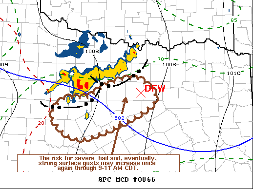
   Mesoscale Discussion 0866
   NWS Storm Prediction Center Norman OK
   0719 AM CDT Mon Jun 07 2021

   Areas affected...Parts of north central Texas

   Concerning...Severe Thunderstorm Watch 241...

   Valid 071219Z - 071415Z

   The severe weather threat for Severe Thunderstorm Watch 241
   continues.

   SUMMARY...While the severe weather risk has diminished in the near
   term, potential exists for substantive renewed intensification and
   organization, which may lead to increasing risk for severe hail and
   strong surface gusts near or just south of the Dallas-Fort Worth
   Metroplex by 9-11 AM CDT.

   DISCUSSION...Strongest new thunderstorm development has become
   focused on the southern/southwestern flank of conglomerate
   convective outflow.  This is where large-scale ascent is supported
   by weak lower/mid tropospheric warm advection, along the
   northeastern periphery of warmer and more strongly capping elevated
   mixed-layer air.  This is also beneath modest to weak westerly to
   northwesterly flow, in the wake of weak large-scale mid-level
   troughing slowly shifting into the Mississippi Valley.  The remnant
   nocturnal low-level jet probably contributed to enhancement of this
   lift, but this forcing is in the process of weakening.

   Still, with a continued slow southward suppression of the elevated
   mixed-layer air across north central Texas, coupled with a gradual
   warming of the seasonably moist boundary layer characterized by
   mixed-layer CAPE in excess of 3000 J/kg, there appears potential for
   substantive thunderstorm intensification and upscale growth through
   14-16Z.   Intersecting outflow surges from one remnant cluster of
   storms now northwest of the Dallas-Fort Worth Metroplex, and the
   newer cluster to the west, may provide one potential focus for
   intensifying and increasingly organized convection near or just
   south of Fort Worth.  Given the environment, this gradually may be
   accompanied by strengthening rear inflow/downdrafts and increasing
   potential for strong surface gusts.

   ..Kerr.. 06/07/2021

   ...Please see www.spc.noaa.gov for graphic product...

   ATTN...WFO...FWD...SJT...

   LAT...LON   32599858 32839817 32969782 33039748 33019712 32479679
               31669869 32119951 32549923 32599858
|


 @NWSSPC