|
| Mesoscale Discussion 886 |
|
< Previous MD Next MD >
|
|
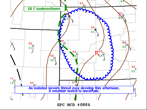
   Mesoscale Discussion 0886
   NWS Storm Prediction Center Norman OK
   0324 PM CDT Tue Jun 08 2021

   Areas affected...Western South Dakota

   Concerning...Severe potential...Watch unlikely

   Valid 082024Z - 082200Z

   Probability of Watch Issuance...20 percent

   SUMMARY...A gradually destabilizing atmosphere may support isolated
   strong to severe storm development across western South Dakota in
   the next couple of hours. Uncertainty on storm coverage/severe
   potential remains high suggesting a watch is unlikely.

   DISCUSSION...Afternoon visible satellite data showed an area of
   towering cumulus/immature thunderstorms developing across western
   south Dakota in advance of a shortwave trough across the central
   Rockies. The 19z observed sounding from UNR shows a deep and
   well-mixed boundary layer with little remaining MLCINH and lapse
   rates approaching 9 C/km. Plentiful buoyancy for strong updrafts
   exists from SPC Mesoanalysis, with surface temps/dewpoints in the
   mid 90s and low 60s F contributing to 2000-3000 J/kg of MLCAPE.
   Vertical shear is somewhat displaced from the developing storms as
   the primary shortwave trough and flow remain to the west. While
   uncertain, an increase in severe potential is possible as greater
   background ascent/deeper flow aloft begin to overspread western
   South Dakota in the next few hours. Damaging wind gusts appear to
   the primary threat given steep mid and low-level lapse rates, though
   isolated severe hail will also be possible given the degree of
   destabilization. Given the limited spatial coverage/severe potential
   expected a watch is unlikely.

   ..Lyons/Guyer.. 06/08/2021

   ...Please see www.spc.noaa.gov for graphic product...

   ATTN...WFO...ABR...UNR...

   LAT...LON   45820289 45660214 45190137 44110113 43420123 43110161
               43060260 43470333 44240386 44510399 44980398 45600367
               45820289
|
|
Top/All Mesoscale Discussions/Forecast Products/Home
|
|


 @NWSSPC