|
| Mesoscale Discussion 895 |
|
< Previous MD Next MD >
|
|
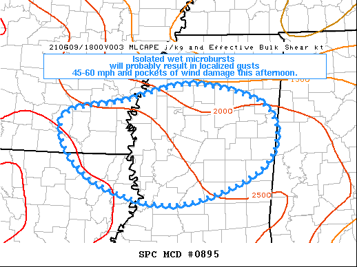
   Mesoscale Discussion 0895
   NWS Storm Prediction Center Norman OK
   1206 PM CDT Wed Jun 09 2021

   Areas affected...central into northern MS...far southeast AR...far
   northeast LA

   Concerning...Severe potential...Watch unlikely

   Valid 091706Z - 091930Z

   Probability of Watch Issuance...20 percent

   SUMMARY...Isolated wet microbursts will probably result in localized
   gusts 45-60 mph and pockets of wind damage this afternoon.  The
   disorganized character of the thunderstorm threat will likely
   preclude a severe thunderstorm watch from being issued.

   DISCUSSION...Visible satellite/radar mosaic shows developing
   thunderstorms over north-central MS and a separate thunderstorm
   cluster intersecting trailing outflow over northwest MS.  Cloud
   breaks over north-central MS and mostly clear skies over central MS
   will favor strong heating for the next few hours as temperatures
   warm into the mid-upper 80s deg F.  A very moist airmass,
   characterized by low-mid 70s dewpoints and PW around 2 inches, will
   further destabilize and yield around 2500-3000 J/kg MLCAPE by early
   afternoon.  Weak flow through the troposphere will result in
   slow-moving cells and clusters.  The main threat with the stronger
   water-loaded cores (higher echo tops and marginally severe MESH
   cores) will be localized gusts in the 45-60 mph range.  Pockets of
   tree damage are anticipated to be the primary end-result with the
   most intense storms.

   ..Smith/Guyer.. 06/09/2021

   ...Please see www.spc.noaa.gov for graphic product...

   ATTN...WFO...MEG...JAN...LZK...SHV...

   LAT...LON   33609252 33899125 34178995 33768845 32828855 32209030
               32649199 33609252
|
|
Top/All Mesoscale Discussions/Forecast Products/Home
|
|


 @NWSSPC