|
| Mesoscale Discussion 897 |
|
< Previous MD Next MD >
|
|
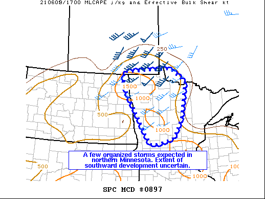
   Mesoscale Discussion 0897
   NWS Storm Prediction Center Norman OK
   0108 PM CDT Wed Jun 09 2021

   Areas affected...Portions of northern Minnesota

   Concerning...Severe potential...Watch unlikely

   Valid 091808Z - 092015Z

   Probability of Watch Issuance...5 percent

   SUMMARY...Damaging winds and isolated large hail will be possible
   this afternoon before storms move north of the international border
   in northern Minnesota. Storms may develop into central Minnesota,
   but uncertainty in coverage and intensity are greater. A WW is not
   expected this afternoon.

   DISCUSSION...Isolated storms have developed near the international
   border and in northwest Minnesota in association with a weak frontal
   wave cyclone/MCV. Effective shear magnitudes may approach 50 kts in
   close proximity to the MCV with a decrease with southward extent.
   The strongest storms are expected to occur in northern Minnesota
   where the most favorable overlap of buoyancy and shear will exist.
   The 12Z INL sounding sampled 7.5 C/km mid-level lapse rate which
   will promote a threat for large hail. Damaging wind gusts will also
   be possible given strong surface heating. A few storms may also
   develop farther south along a weak convergence zone into parts of
   central Minnesota. There is uncertainty here as the better mid-level
   ascent and shear will remain north and continue to lift away from
   the region this afternoon. Damaging winds would be the more likely
   threat with southward extent, with any large hail being much more
   isolated. A WW is not expected as the strongest storms are expected
   to move into Manitoba/Ontario relatively quickly.

   ..Wendt/Guyer.. 06/09/2021

   ...Please see www.spc.noaa.gov for graphic product...

   ATTN...WFO...DLH...MPX...FGF...

   LAT...LON   46399606 48409740 49099749 49249443 48639345 47069379
               46219428 45959524 45939570 46399606
|
|
Top/All Mesoscale Discussions/Forecast Products/Home
|
|


 @NWSSPC