|
| Mesoscale Discussion 910 |
|
< Previous MD Next MD >
|
|
Mesoscale Discussion 0910
NWS Storm Prediction Center Norman OK
0536 PM CDT Thu Jun 10 2021
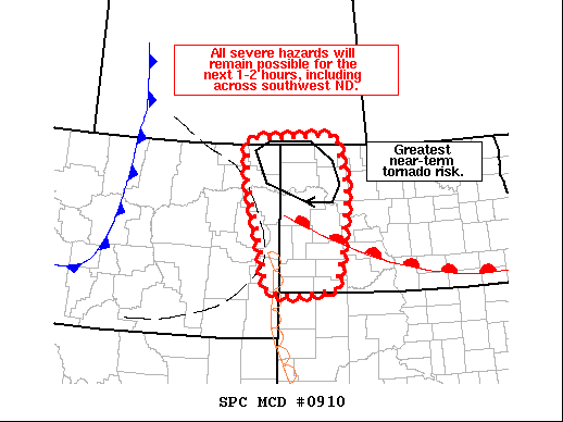
Areas affected...Western North Dakota and far eastern Montana
Concerning...Tornado Watch 251...
Valid 102236Z - 110030Z
The severe weather threat for Tornado Watch 251 continues.
SUMMARY...All hazards will remain possible for the next 1-2 hours,
including across southwest North Dakota. The greatest near-term
tornado risk will likely remain across northwest North Dakota where
stronger low-level shear is noted.
DISCUSSION...Radar imagery from KGGW and KMBX show discrete to
semi-discrete cells continuing to mature along the surface
trough/dryline across far eastern Montana. Several severe hail
reports have been noted in the past hour with this activity, as well
as organized mesocyclones with the stronger, more persistent storms.
Additionally, new convection is attempting to develop along the
dryline across southwest North Dakota. Although low-level winds are
slightly more veered out of the south across this region, effective
SRH values near 100-200 m2/s2 will support a tornado risk with any
discrete storm that can develop.
Further north, more easterly flow to the north of a diffuse surface
warm front is supporting higher ESRH values up to 400 m2/s2 per
recent RAP Mesoanalysis estimates. This favorable shear, coupled
with moderate to high instability owing to surface dewpoints in the
mid 60s, is supporting STP values between 3-4 within a narrow zone
across northwest ND. This region may see the highest tornado
potential in the near-term as storms move from eastern MT into this
environment. The duration and coverage of the tornado threat remains
somewhat uncertain given boundary-parallel mid-level flow and the
potential for storm interactions. However, more zonal effective
shear vectors across western ND may continue to support discrete
modes as storms progress eastward this evening.
..Moore.. 06/10/2021
...Please see www.spc.noaa.gov for graphic product...
ATTN...WFO...BIS...UNR...BYZ...GGW...
LAT...LON 48260502 49100505 49160384 49180227 48000198 46700219
46030237 45930318 45890386 45950439 47100466 48260502
|
|
Top/All Mesoscale Discussions/Forecast Products/Home
|
|


 @NWSSPC