|
| Mesoscale Discussion 940 |
|
< Previous MD Next MD >
|
|
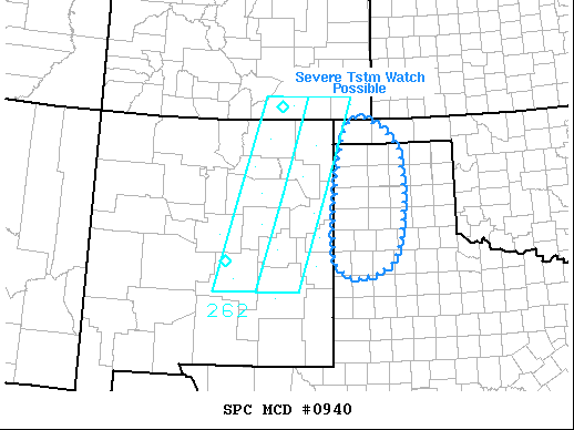
   Mesoscale Discussion 0940
   NWS Storm Prediction Center Norman OK
   0923 PM CDT Sat Jun 12 2021

   Areas affected...Western portions of the Oklahoma and Texas
   Panhandle Region

   Concerning...Severe potential...Watch possible

   Valid 130223Z - 130330Z

   Probability of Watch Issuance...60 percent

   SUMMARY...Severe thunderstorm watch may be warranted for western
   portions of the Oklahoma and Texas Panhandle region. Damaging winds
   and large hail are the primary risks.

   DISCUSSION...Convection that developed off the higher terrain from
   southeast CO into central NM has finally developed enough mass/cold
   pool to begin propagating southeast away from the initiating
   region/steeper low-level lapse rates. 00z sounding from AMA
   exhibited a weak cap near 700mb, but with a 70F surface dew point
   MLCAPE was ~3700 J/kg. There is some concern this activity may
   spread east of ww262 as east-southeast boundary-layer inflow is
   quite moist and potentially buoyant. Severe thunderstorm watch may
   be warranted soon to account for this threat.

   ..Darrow/Dial.. 06/13/2021

   ...Please see www.spc.noaa.gov for graphic product...

   ATTN...WFO...LUB...AMA...

   LAT...LON   34040294 36870265 36340139 34160155 34040294
|
|
Top/All Mesoscale Discussions/Forecast Products/Home
|
|


 @NWSSPC