|
| Mesoscale Discussion 965 |
|
< Previous MD Next MD >
|
|
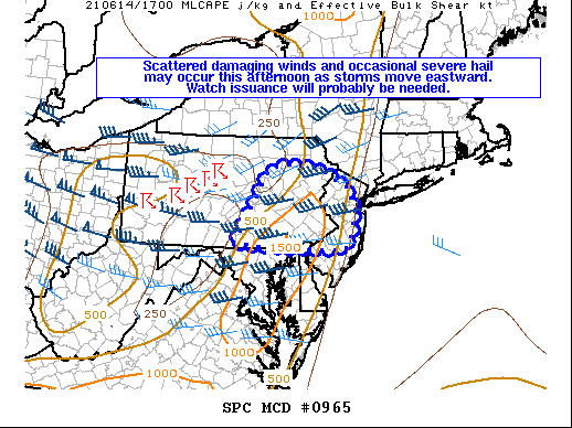
   Mesoscale Discussion 0965
   NWS Storm Prediction Center Norman OK
   1240 PM CDT Mon Jun 14 2021

   Areas affected...Portions of central/eastern PA...NJ...and far
   northern DE

   Concerning...Severe potential...Watch possible

   Valid 141740Z - 142015Z

   Probability of Watch Issuance...60 percent

   SUMMARY...Scattered damaging wind gusts and occasional severe hail
   may occur this afternoon as storms move eastward. Watch issuance
   will probably be needed.

   DISCUSSION...A broken line of storms has developed early this
   afternoon along a surface cold front across parts of western/central
   PA. A belt of 40-50+ kt mid-level west-southwesterly winds
   associated with a shortwave trough will likely foster continued
   storm organization given the presence of elongated, nearly straight
   hodographs at mid/upper levels. A mainly linear storm mode should
   support a continued risk of damaging wind gusts, particularly as
   low-level lapse rates continue to steepen ahead of the ongoing
   activity via diurnal heating. Some short-term, convection-allowing
   model guidance suggests convection may struggle as it crosses the
   higher terrain of the Appalachians and encounters a minimum in
   boundary-layer instability. But, these storms may tend to intensify
   later this afternoon once they encounter a more unstable airmass
   characterized by 1000-1500 J/kg MLCAPE and low to mid 60s surface
   dewpoints across eastern PA into NJ and vicinity. The timing for a
   potential downstream Severe Thunderstorm Watch across
   central/eastern PA and NJ remains a bit uncertain given the
   possibility that the ongoing storms may weaken some in the
   short-term as they move eastward into central PA. Still, a watch
   will probably be needed at some point this afternoon.

   ..Gleason/Grams.. 06/14/2021

   ...Please see www.spc.noaa.gov for graphic product...

   ATTN...WFO...OKX...PHI...BGM...CTP...

   LAT...LON   39837750 41377658 41437613 41377523 40997449 40867441
               40487428 40047433 39697455 39707534 39757693 39837750
|
|
Top/All Mesoscale Discussions/Forecast Products/Home
|
|


 @NWSSPC