|
| Mesoscale Discussion 982 |
|
< Previous MD Next MD >
|
|
Mesoscale Discussion 0982
NWS Storm Prediction Center Norman OK
0734 PM CDT Tue Jun 15 2021
Areas affected...Southern Nebraska and far northern Kansas
Concerning...Severe potential...Watch unlikely
Valid 160034Z - 160230Z
Probability of Watch Issuance...5 percent
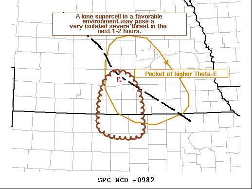
SUMMARY...A single supercell may pose a very isolated severe
wind/hail risk to south-central Nebraska over the next 1-2 hours.
The coverage of the threat should be minimal, and the duration may
not extend beyond a couple of hours. A watch is not expected.
DISCUSSION...A single thunderstorm has developed across
south-central NE over the past hour. While this region has moderate
mixed-layer instability and nearly 40 knots of effective bulk shear,
a strong cap largely remains in place. A pocket of higher theta-e
air across south-central NE lies within a weak confluence axis,
which has led to a local weakening of the cap that has allowed the
thunderstorm to develop. Recent GOES trends show some degree of
cloud-top cooling with splitting supercell structures noted in KUEX
imagery. This suggests that the supercell is robust enough to
persist for at least one to two hours despite the weak forcing for
ascent. Additional convection along the confluence axis in the high
theta-e pocket is possible (as indicated by a couple of weak
convective towers), but is not likely. Severe hail/wind are possible
with this storm, but the duration is uncertain after 02 UTC given
the onset of diurnal cooling.
..Moore/Guyer.. 06/16/2021
...Please see www.spc.noaa.gov for graphic product...
ATTN...WFO...GID...
LAT...LON 40809920 40989895 40959857 40779835 40509821 40189813
39889811 39579807 39479835 39489872 39519908 39699941
40169940 40529932 40809920
|
|
Top/All Mesoscale Discussions/Forecast Products/Home
|
|


 @NWSSPC