|
| Mesoscale Discussion 990 |
|
< Previous MD Next MD >
|
|
Mesoscale Discussion 0990
NWS Storm Prediction Center Norman OK
0702 PM CDT Thu Jun 17 2021
Areas affected...South-Central/Southeast MN...West-Central
WI...North-Central/Northeast IA
Concerning...Severe Thunderstorm Watch 276...
Valid 180002Z - 180130Z
The severe weather threat for Severe Thunderstorm Watch 276
continues.
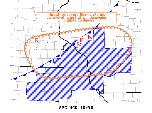
SUMMARY...The threat for severe thunderstorms continues across much
of the Upper MS Valley. Large hail is the primary threat, with some
damaging wind gusts possible as well. Parts of
south-central/southeast MN are being monitored for additional watch
issuance.
DISCUSSION...Recent surface analysis places the cold front from
about 10 miles east-southeast of EAU southwestward through
south-central MN and far northwest IA. A corridor of slightly higher
dewpoints exists along this frontal boundary, with mid 60s dewpoints
extending into far west-central WI. A few storms have developed
along this front in far west-central WI, where surface temperatures
were a few degrees higher, which resulted in less convective
inhibition. Environment near these storms supports strong updrafts
and the potential for quick upscale growth on storm outflow. Severe
threat with these storms will likely persist into more of central
WI.
Farther west (across southwest MN), a few storms have recently
developed, likely as a result of persistent warm air advection
across the region. Character of the reflectivity also suggests thee
storms are elevated. Steep mid-level lapse rates and resulting
strong buoyancy could result in a few updrafts capable of producing
large hail. Some additional development appears possible across this
area with new echos now beginning to appear. Overall storm coverage
remains uncertain given the warm low to mid-level temperatures and
resulting convective inhibition. However, persistent isentropic
ascent coupled with the approach of a subtle vorticity maximum and
southward pushing 850mb front suggest potential for additional
storms.
..Mosier/Guyer.. 06/18/2021
...Please see www.spc.noaa.gov for graphic product...
ATTN...WFO...GRB...MKX...ARX...MPX...DMX...
LAT...LON 44449451 44889213 45038995 44738908 44158899 43389005
43209213 43249378 44449451
|
|
Top/All Mesoscale Discussions/Forecast Products/Home
|
|


 @NWSSPC