|
| Mesoscale Discussion 993 |
|
< Previous MD Next MD >
|
|
Mesoscale Discussion 0993
NWS Storm Prediction Center Norman OK
0134 AM CDT Fri Jun 18 2021
Areas affected...Far Southeast Minnesota...Far Northeast
Iowa...South-central Wisconsin
Concerning...Severe Thunderstorm Watch 278...
Valid 180634Z - 180830Z
The severe weather threat for Severe Thunderstorm Watch 278
continues.
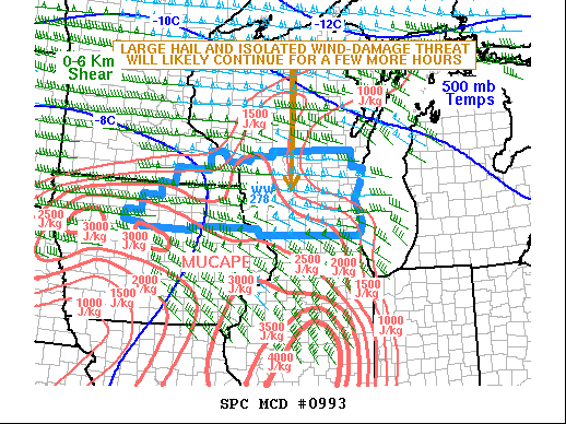
SUMMARY...A threat for large hail and isolated wind damage will
likely continue for a few more hours. The threat will probably be
greatest across south-central Wisconsin where a cluster of strong
thunderstorms is ongoing. The storms are expected to decrease in
intensity as they move eastward toward Lake Michigan where
instability is weaker.
DISCUSSION...The latest surface analysis shows a 1004 mb low over
far northeast Iowa with a quasi-stationary front extending eastward
across south-central Wisconsin. An east-to-west line of strong to
severe thunderstorms is ongoing near the front. The RAP is showing
moderate instability across south-central Wisconsin with generally
weaker instability with eastward extent. MUCAPE is estimated near
2500 J/Kg in southwest Wisconsin and near 1000 J/kg in southeast
Wisconsin. Effective shear is estimated near 50 kt across much of
south-central Wisconsin which will likely support a severe threat
for a few more hours. The instability, shear and steep mid-level
lapse rates evident on forecast soundings, will be favorable for
large hail with the stronger updrafts. Concerning the wind-damage
potential, the RAP is showing CIN values in south-central Wisconsin
in the -200 to -300 J/kg range. This will make it difficult for the
stronger storms to produce wind damage. Any wind-damage potential
should remain relatively isolated.
..Broyles.. 06/18/2021
...Please see www.spc.noaa.gov for graphic product...
ATTN...WFO...MKX...ARX...
LAT...LON 43918999 43859153 43519189 43079179 42929141 42948930
42938769 43328741 43768786 43918999
|
|
Top/All Mesoscale Discussions/Forecast Products/Home
|
|


 @NWSSPC