Mesoscale Discussion 1061
NWS Storm Prediction Center Norman OK
1158 AM CDT Tue Jun 22 2021
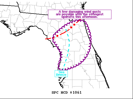
Areas affected...Northern FL
Concerning...Severe potential...Watch unlikely
Valid 221658Z - 221900Z
Probability of Watch Issuance...20 percent
SUMMARY...A few damaging wind gusts are possible with the strongest
storms this afternoon.
DISCUSSION...Recent surface analysis shows a convectively enhanced
outflow boundary moving across northern FL. This boundary is well
ahead of the cold front, which is currently moving through central
GA. Given the buoyancy downstream, expectation is for the ongoing
activity to continue. Thus far, updrafts have been relatively
short-lived, likely as a result of poor vertical shear and
progressive nature of the outflow boundary undercutting ongoing
storms.
Surface analysis and visible satellite imagery also show the west
coast sea-breeze, which is delineated fairly well by the 88 deg F
isotherm. Storms have begun developing along the sea-breeze. Weakly
sheared environment suggests a short life cycle with most updrafts.
Even so, ample moisture exists for water loading, and a few stronger
downdrafts are possible. Additionally, storms along the
southward-moving outflow could merge with those developing along the
sea breeze, augmented updrafts/downdrafts. Limited
severe coverage is currently anticipated, but overall convective
trends will be monitored closely.
..Mosier/Hart.. 06/22/2021
...Please see www.spc.noaa.gov for graphic product...
ATTN...WFO...MLB...TBW...JAX...TAE...
LAT...LON 29618302 30218224 30338150 30058126 29598113 28898125
28368179 28148269 28818258 29258285 29618302
|


 @NWSSPC