|
| Mesoscale Discussion 1066 |
|
< Previous MD Next MD >
|
|
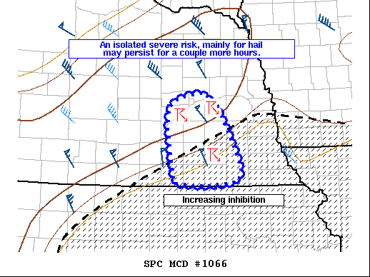
   Mesoscale Discussion 1066
   NWS Storm Prediction Center Norman OK
   0951 PM CDT Tue Jun 22 2021

   Areas affected...east-central Nebraska

   Concerning...Severe potential...Watch unlikely

   Valid 230251Z - 230345Z

   Probability of Watch Issuance...5 percent

   SUMMARY...Lingering strong/severe storms may pose an isolated risk
   for severe hail over the next couple hours.

   DISCUSSION...North of the previous severe convection across
   southeastern Nebraska, two elevated supercells have recently evolved
   in the warm advection regime across York, Polk, and Butler Counties.
   An uptick in lightning and radar reflectivity over the last 20
   minutes suggests these storms may strengthen temporarily over the
   next hour. This redevelopment is likely a result of increased
   forcing associated with the nocturnal low-level jet. SPC
   mesoanalysis indicates these storms are ongoing near the
   southeastern edge of a plume of 500-1000 J/kg of MUCAPE. Vertical
   shear profiles remain supportive of supercells with 40 kts of
   effective shear observed by the 00z OAX sounding. The severe risk
   with these storms will likely be short lived as they continue to
   move south into an increasingly stable airmass. Over the next hour
   or two, isolated severe hail will remain possible before storms
   permanently weaken below severe limits.

   ..Lyons/Grams.. 06/23/2021

   ...Please see www.spc.noaa.gov for graphic product...

   ATTN...WFO...OAX...GID...

   LAT...LON   40029761 40059799 40579809 40959812 41279811 41429786
               41489737 41129701 40309661 40089668 40029722 40029761
|
|
Top/All Mesoscale Discussions/Forecast Products/Home
|
|


 @NWSSPC