|
| Mesoscale Discussion 1101 |
|
< Previous MD Next MD >
|
|
Mesoscale Discussion 1101
NWS Storm Prediction Center Norman OK
0705 PM CDT Fri Jun 25 2021
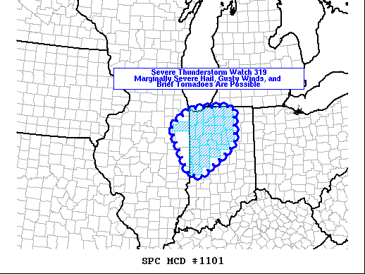
Areas affected...northwest Indiana
Concerning...Severe Thunderstorm Watch 319...
Valid 260005Z - 260100Z
The severe weather threat for Severe Thunderstorm Watch 319
continues.
SUMMARY...Thunderstorms will continue to develop northeastward out
of central Illinois into northwest Indiana this evening. Marginally
severe hail, gusty winds, and a brief tornado will be possible.
DISCUSSION...Thunderstorms are expected to continue developing
northeastward this evening. Surface dewpoints in the low 70s and
temperatures in the low 80s will maintain most-unstable CAPE values
up to 1000 J/kg. This should be maintained into the evening as the
low-level jet develops this evening and maintains low-level theta-e.
This should support at least a marginally severe hail threat and
potential for strong thunderstorm outflow. Additionally, a myriad of
outflow boundaries from earlier convection remain across the area.
Any thunderstorm updraft that latches onto one of these boundaries
may result in a brief tornado.
..Marsh.. 06/26/2021
...Please see www.spc.noaa.gov for graphic product...
ATTN...WFO...IWX...IND...LOT...ILX...
LAT...LON 39598701 39598703 39608753 40998825 41108825 41208824
41718752 41718752 41758682 41758613 41758604 41758566
41588566 41488565 40918564 40858564 40658564 40418586
39598701 39598701
|
|
Top/All Mesoscale Discussions/Forecast Products/Home
|
|


 @NWSSPC