|
| Mesoscale Discussion 1135 |
|
< Previous MD Next MD >
|
|
Mesoscale Discussion 1135
NWS Storm Prediction Center Norman OK
0316 PM CDT Wed Jun 30 2021
Areas affected...Portions of southern NH and coastal ME
Concerning...Severe Thunderstorm Watch 326...
Valid 302016Z - 302145Z
The severe weather threat for Severe Thunderstorm Watch 326
continues.
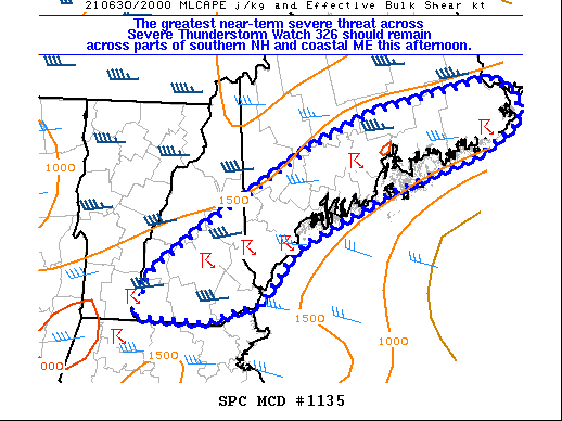
SUMMARY...The greatest near-term severe threat across Severe
Thunderstorm Watch 326 should remain across parts of southern New
Hampshire and coastal Maine this afternoon.
DISCUSSION...A narrow corridor of moderate instability (MLCAPE of
1500 J/kg) remains present generally ahead of ongoing storms across
parts of southern NH and coastal ME. Recent VWP from KGYX shows
strong flow remains present in the 4-8 km layer AGL, with around
40-50 kt of westerly winds estimated. Convection has shown signs of
continued organization with around 40 kt of effective bulk shear,
and a mix of marginal supercells and multicells has been observed
over the past couple of hours. Occasional severe hail and strong to
locally damaging winds are expected to to remain the primary severe
threat as storms continue to move eastward towards the coast. The
greatest damaging wind threat may focus with a small cluster of
storms moving eastward across southern NH and vicinity, as low-level
lapse rates are steepest there.
..Gleason.. 06/30/2021
...Please see www.spc.noaa.gov for graphic product...
ATTN...WFO...CAR...GYX...
LAT...LON 42787248 43217233 43657167 44557001 44916908 45246733
45056695 44786694 44486749 44076890 43537021 42937076
42857114 42747150 42787248
|
|
Top/All Mesoscale Discussions/Forecast Products/Home
|
|


 @NWSSPC