|
| Mesoscale Discussion 1157 |
|
< Previous MD Next MD >
|
|
Mesoscale Discussion 1157
NWS Storm Prediction Center Norman OK
0544 PM CDT Mon Jul 05 2021
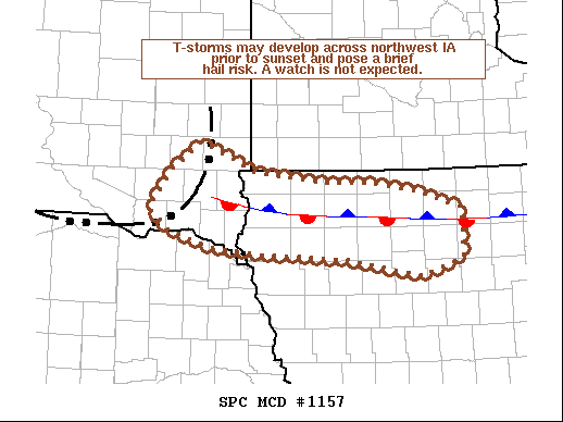
Areas affected...Far southeast South Dakota into northwest Iowa
Concerning...Severe potential...Watch unlikely
Valid 052244Z - 060045Z
Probability of Watch Issuance...5 percent
SUMMARY...Thunderstorms may develop along a stationary boundary
across northwest to north-central Iowa prior to sunset, though the
potential for additional storms is uncertain. However, storms that
do form could pose a brief severe hail risk.
DISCUSSION...Recent satellite imagery continues to show a generally
shallow cumulus field along a stationary boundary draped across
northern IA. Despite the meager appearance of the cumulus field, new
convection has been intensifying at the intersection of the boundary
and convective outflow from an upstream cluster of storms across
southeast SD. Although lift is locally augmented at this
intersection, objective analysis trends over the past hour suggest
convergence may be gradually increasing along the stationary
boundary across northwest IA, and RAP forecast soundings hint that
low-level parcels are near their convective temperatures. This
suggests that an isolated thunderstorm or two could develop either
1) along the stationary boundary (likely prior to sunset and the
onset of boundary-layer stabilization) or 2) along the convective
outflow as it gradually pushes east through the evening hours.
Confidence in either solution is somewhat low, and storm chances
decrease with eastward extent due to weaker convergence/implied
ascent. Given moderate instability in place (upwards of 3000 J/kg
MLCAPE), any storms that do form may initially be capable of
producing severe hail, though the lack of sufficient deep-layer
shear will limit the duration of this threat. Given the lack of
confidence in storm coverage and low potential for robust storm
organization, a watch is not expected.
..Moore/Hart.. 07/05/2021
...Please see www.spc.noaa.gov for graphic product...
ATTN...WFO...DMX...FSD...OAX...
LAT...LON 43519755 43799713 43489638 43379539 43369469 43279407
43099342 42579342 42389401 42569502 42639637 42699702
42889763 43099788 43519755
|
|
Top/All Mesoscale Discussions/Forecast Products/Home
|
|


 @NWSSPC