|
| Mesoscale Discussion 1245 |
|
< Previous MD Next MD >
|
|
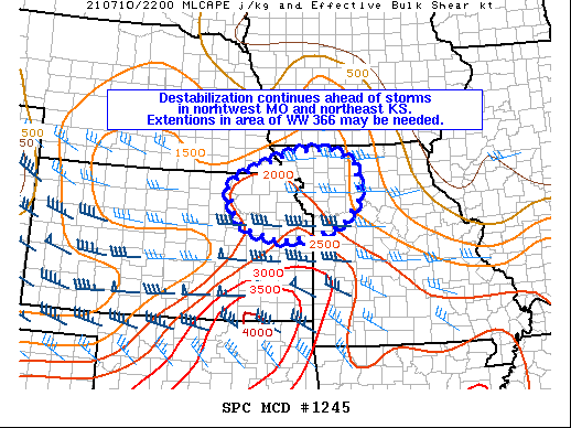
   Mesoscale Discussion 1245
   NWS Storm Prediction Center Norman OK
   0527 PM CDT Sat Jul 10 2021

   Areas affected...Northeast Kansas and Northwest Missouri

   Concerning...Severe Thunderstorm Watch 366...

   Valid 102227Z - 110030Z

   The severe weather threat for Severe Thunderstorm Watch 366
   continues.

   SUMMARY...A line of thunderstorms along the Missouri River will
   continue southeast into a slightly more favorable environment for
   damaging wind gusts and perhaps large hail. Local extensions in area
   of WW 366 may be needed.

   DISCUSSION...In the wake of thunderstorm complexes overnight
   yesterday into this morning, airmass recovery has continued this
   afternoon in eastern Kansas and western Missouri. Temperatures have
   risen in the low to mid 80s F, which is slightly higher than
   RAP/HRRR forecast guidance has shown. As such MLCAPE may a bit
   higher in some locations than the objectively analyzed 2000-2500
   J/kg. As the line of convection continues to the southeast, the
   environment will be more supportive of damaging wind gusts as well
   as large hail. A few storms have tried to develop ahead of the line
   and these more discrete storms would pose the greatest large hail
   risk. Storms should be maintained with forcing from the mid-level
   shortwave and associated deep-layer shear. With storms nearing the
   edge of WW 366, local extensions in area may be needed to address
   the continue threat for severe storms this afternoon into the early
   evening.

   ..Wendt.. 07/10/2021

   ...Please see www.spc.noaa.gov for graphic product...

   ATTN...WFO...EAX...OAX...TOP...

   LAT...LON   39699687 39909665 40459524 40519421 40209349 39499341
               38949385 38719480 38649549 38809617 38889642 39129668
               39699687
|
|
Top/All Mesoscale Discussions/Forecast Products/Home
|
|


 @NWSSPC