|
| Mesoscale Discussion 1264 |
|
< Previous MD Next MD >
|
|
Mesoscale Discussion 1264
NWS Storm Prediction Center Norman OK
1051 AM CDT Mon Jul 12 2021
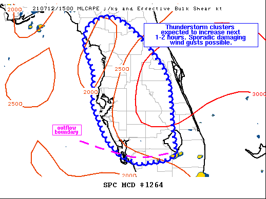
Areas affected...portions of the FL Peninsula
Concerning...Severe potential...Watch possible
Valid 121551Z - 121745Z
Probability of Watch Issuance...40 percent
SUMMARY...Sporadic strong, locally damaging wind gusts and hail will
be possible with more intense thunderstorms this afternoon across
parts of the Florida Peninsula.
DISCUSSION...Thunderstorms are developing across southern FL, moving
toward the central peninsula, in the vicinity of an outflow boundary
from overnight/early morning convection. Additional convection is
also beginning to develop over eastern portions of the peninsula in
developing sea breeze and deep southeasterly flow. Moderate to
strong instability is already in place with dewpoints well into the
70s F amid strong surface heating and modest midlevel cooling.
Little to no inhibition remains over the region, and convection
should continue to increase in coverage over the next couple of
hours as storms track toward the northwest.
Deep layer flow will generally remain weak over the region and this
will inhibit storm organization somewhat. Nevertheless, steep
midlevel lapse rates and strong instability should compensate and
allow for at least briefly intense cells within thunderstorm
clusters. High PW values also will help contribute to damaging wind
potential via wet microburst processes. Some hail also could briefly
accompany any more intense cells, but longevity of intense updrafts
should remain limited given weak vertical shear. Trends will be
monitored for possible watch issuance this afternoon.
..Leitman/Dial.. 07/12/2021
...Please see www.spc.noaa.gov for graphic product...
ATTN...WFO...MFL...MLB...TBW...JAX...TAE...
LAT...LON 29628308 29828274 29798232 29608200 29198155 28618109
28288095 27158086 26668081 26608082 26538103 26448175
26648220 26998255 27768291 28538290 29198318 29558314
29628308
|
|
Top/All Mesoscale Discussions/Forecast Products/Home
|
|


 @NWSSPC