Mesoscale Discussion 1296
NWS Storm Prediction Center Norman OK
0401 PM CDT Thu Jul 15 2021
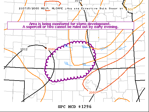
Areas affected...South-central KS...north-central OK
Concerning...Severe potential...Watch unlikely
Valid 152101Z - 152300Z
Probability of Watch Issuance...20 percent
SUMMARY...Convection is expected to increase by early evening. A few
organized storms are possible, posing a threat of damaging wind and
perhaps a brief tornado.
DISCUSSION...Clearing in the wake of an MCV moving across
south-central KS has resulted in moderate destabilization, with
MLCAPE of 1500-2000 J/kg and minimal MLCINH noted in areas where
some heating has occurred, per recent mesoanalyses. Modest but
veering flow aloft is supporting effective shear of 25-35 kt, with
the higher shear values noted where surface winds remain relatively
backed, as noted in recent VWP data from KICT.
Guidance suggests storms will develop by late afternoon/early
evening across south-central KS into northwest/north-central OK,
which is supported by increasing cumulus noted in recent VIS
imagery. Effective shear will support organized convection as storms
mature, and a supercell or two cannot be ruled out if any storms can
be sustained into the favorable wind profile that will reside to the
east of the most likely initiation zone. Locally damaging wind will
be possible with any stronger storm across this region, and any
supercell may pose a conditional risk of a brief tornado.
Watch issuance is currently considered unlikely, given uncertainties
regarding storm coverage in the short term and evolution of the
mesoscale details, but trends will continue to be monitored for the
potential of isolated supercell development.
..Dean/Bunting.. 07/15/2021
...Please see www.spc.noaa.gov for graphic product...
ATTN...WFO...ICT...OUN...DDC...
LAT...LON 37039679 36759710 36549868 36899898 37369888 37769841
38049761 38019691 37709663 37289660 37039679
|


 @NWSSPC