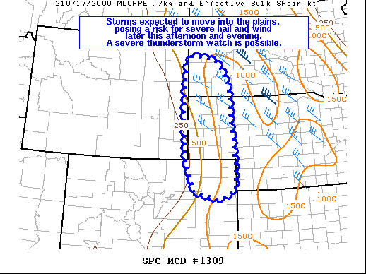
   Mesoscale Discussion 1309
   NWS Storm Prediction Center Norman OK
   0340 PM CDT Sat Jul 17 2021

   Areas affected...Western South Dakota...Nebraska Panhandle...and
   Northeastern Colorado

   Concerning...Severe potential...Watch possible

   Valid 172040Z - 172315Z

   Probability of Watch Issuance...40 percent

   SUMMARY...Storms developing over the high terrain are expected to
   eventually move eastward into the High Plains, posing a risk for
   severe hail and wind.  The coverage of severe storms remains
   uncertain, so convective trends will be monitored for the
   possibility of a severe thunderstorm watch.

   DISCUSSION...Even though midlevel heights are rising across the
   area, an impulse rounding the top of the ridge has contributed to
   thunderstorm initiation over the high terrain of central
   Colorado/Wyoming and Black Hills of South Dakota.  Substantial
   convective inhibition remains over the plains, as indicated by the
   20Z UNR sounding (170 J/kg of MLCIN), which will likely delay the
   threat and limit the eastward extent. Nevertheless, strong heating
   will continue to remove the convective inhibition through the
   afternoon, yielding ~1000 J/kg of MLCAPE with 30-40 knots of
   effective bulk shear by late afternoon/evening (per latest RAP).
   This environment should support organized storm modes that pose a
   threat for severe hail initially (midlevel lapse rates around 8
   C/km), followed by a transition to a wind threat as storms merge
   into one or more southward-moving clusters, perhaps aided by a
   southeasterly low-level jet after 02Z.  Significant uncertainty
   remains regarding storm coverage, longevity, and evolution, so
   convective trends will be monitored for the possibility of a watch.

   ..Jirak/Dial.. 07/17/2021

   ...Please see www.spc.noaa.gov for graphic product...

   ATTN...WFO...LBF...UNR...GLD...BOU...CYS...

   LAT...LON   40000377 41000413 42510419 43440414 44100404 44300386
               44280333 44180286 43910261 43570235 43140226 42370220
               41650215 41130210 40650207 40000207 39730276 40000377
|


 @NWSSPC