|
| Mesoscale Discussion 1321 |
|
< Previous MD Next MD >
|
|
Mesoscale Discussion 1321
NWS Storm Prediction Center Norman OK
0612 PM CDT Tue Jul 20 2021
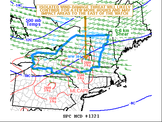
Areas affected...New York and New England
Concerning...Severe Thunderstorm Watch 384...
Valid 202312Z - 210115Z
The severe weather threat for Severe Thunderstorm Watch 384
continues.
SUMMARY...The wind-damage threat inside WW 384 is expected to
continue for several more hours this evening. As the convection
moves to the eastern edge of WW 384, a new watch may be needed.
DISCUSSION...The latest radar imagery from Albany, New York shows
two small clusters of strong to severe thunderstorms. The first is
located to the east of Lake Ontario with the second in northern New
York near the Vermont state line. These convective clusters are
located in a moist airmass with surface dewpoints in the 60s F. This
is contributing to moderate instability with the RAP estimating
MLCAPE in the 1500 to 2000 J/kg range. In addition, moderate
deep-layer shear is present with 0-6 km shear near 35 kt on the
Albany WSR-88D VWP. Th instability, shear combined with steep
low-level lapse rates will support isolated wind damage with the
stronger multicells. The easternmost cluster of strong storms will
likely move into New Hampshire and southern Maine over the next
couple of hours, where instability is weaker but still could support
strong to severe gusts.
..Broyles/Edwards.. 07/20/2021
...Please see www.spc.noaa.gov for graphic product...
ATTN...WFO...GYX...BOX...BTV...ALY...BGM...BUF...
LAT...LON 44767209 44507120 43807103 42977126 42377200 42297385
42347585 42807675 43257670 43787570 44727371 44767209
|
|
Top/All Mesoscale Discussions/Forecast Products/Home
|
|


 @NWSSPC