|
| Mesoscale Discussion 1323 |
|
< Previous MD Next MD >
|
|
Mesoscale Discussion 1323
NWS Storm Prediction Center Norman OK
0932 AM CDT Wed Jul 21 2021
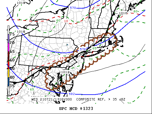
Areas affected...Parts of northern Virginia...the District of
Columbia...central/eastern Maryland...Delaware...southeastern
Pennsylvania...New Jersey...southeastern New York including Long
Island...Connecticut...Rhode Island and southeastern Massachusetts
Concerning...Severe potential...Watch likely
Valid 211432Z - 211530Z
Probability of Watch Issuance...80 percent
SUMMARY...Scattered intensifying thunderstorm development is
possible through Noon-2 PM EDT, posing a risk for at least
marginally severe hail and locally strong surface gusts. With
storms likely to become more widespread thereafter, a severe weather
watch probably will be issued.
DISCUSSION...A slowly southward advancing surface cold front has
reached southeastern New England and the northern Mid Atlantic
coast, with large-scale ascent likely to increase in a corridor
along and ahead of it through early afternoon. This appears likely
to be aided by forcing ahead of substantive mid-level short wave
trough gradually turning east of the lower Great Lakes region.
The strengthening lift will coincide with a narrow pre-frontal
corridor of rapidly steepening near-surface lapse rates aided by
daytime heating. Lower/mid tropospheric lapse rates are also
relatively steep and, despite seasonably modest low-level moisture,
it appears that this will contribute to mixed-layer CAPE in excess
of 1000 J/kg (up to around 2000 J/kg).
Although low-level wind fields are generally weak, 30-50+ kt
cyclonic flow in the 500-300 mb layer is contributing to sufficient
shear to support organizing clusters of storms. Isolated supercells
are possible initially, and these storms may pose a risk for
(mostly) marginally severe hail, before the risk for potentially
damaging wind gusts become more prominent later this afternoon.
Areas of deepening convective development are already evident along
this corridor, and a severe weather watch will probably be issued
within the next hour or two.
..Kerr/Hart.. 07/21/2021
...Please see www.spc.noaa.gov for graphic product...
ATTN...WFO...BOX...OKX...ALY...PHI...AKQ...CTP...LWX...
LAT...LON 41397389 42227140 41367090 40097343 38967544 38087720
38937754 39757718 40267570 41397389
|
|
Top/All Mesoscale Discussions/Forecast Products/Home
|
|


 @NWSSPC