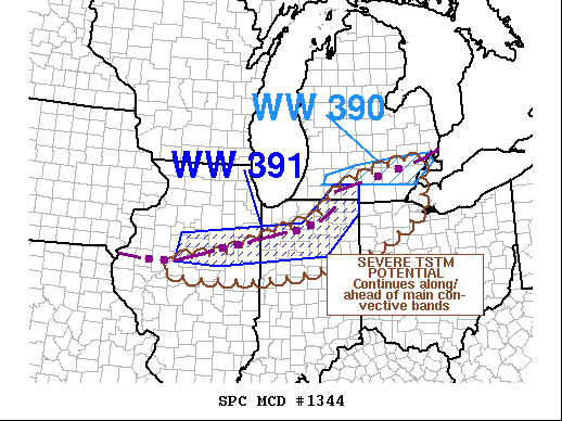
   Mesoscale Discussion 1344
   NWS Storm Prediction Center Norman OK
   0731 PM CDT Sat Jul 24 2021

   Areas affected...portions of southern Lower MI...western Lake
   Erie...northwestern OH...northern IN...and northern/central IL.

   Concerning...Severe Thunderstorm Watch 390...391...

   Valid 250031Z - 250230Z

   The severe weather threat for Severe Thunderstorm Watch 390, 391
   continues.

   SUMMARY...Bands of thunderstorms will continue to offer a threat for
   damaging gusts from central/northeastern IL to southern MI, and a
   pocket of additional tornado potential exists in the southeastern
   Lower MI area.  Another watch may be required in a narrow corridor
   southeast of the existing watches over portions of northwestern OH
   and/or central/northeastern IN.

   DISCUSSION...The most intense band of convection continues to be the
   activity moving southeastward at an erratic/25-35-kt pace across
   southeastern Lower MI.  In addition to damaging gusts, a couple
   tornadoes appear to have occurred in the last hour, within short-
   lived but intense embedded mesocyclones.  This potential will
   continue for another hour or two as the convection encounters a
   pocket of relatively high-SRH air (effective SRH 150-350 J/kg),
   based on radar imagery, VWP analysis and objective mesoanalysis
   data.

   Low-level shear decreases with southwestward extent over IN and
   central IL where surface winds are more veered, generally in step
   with an increase in buoyancy (as represented by a westward-
   broadening, prefrontal corridor of MLCAPE in the 2000-3000 J/kg
   range).  Still, given the available moisture and depth of the
   buoyant layer, water-loaded downdrafts still will be capable of
   localized damaging to severe gusts.  Theta-e and buoyancy will
   continue to diminish with southeastward extent over western OH and
   eastern IN, but activity may continue at or near severe levels past
   the current versions of both watches (in space and time).
   Additional local extensions or a narrow new watch could be needed to
   cover this potential into the evening.

   ..Edwards.. 07/25/2021

   ...Please see www.spc.noaa.gov for graphic product...

   ATTN...WFO...CLE...ILN...DTX...IWX...GRR...IND...LOT...ILX...

   LAT...LON   40478983 40598861 41048714 41468576 41958541 42568333
               42418299 41918312 41568298 40658465 40158715 40158983
               40478983
|


 @NWSSPC