|
| Mesoscale Discussion 1360 |
|
< Previous MD Next MD >
|
|
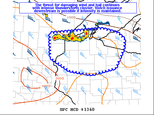
   Mesoscale Discussion 1360
   NWS Storm Prediction Center Norman OK
   0841 PM CDT Mon Jul 26 2021

   Areas affected...East-central MN...Northwest WI...Western Upper MI

   Concerning...Severe Thunderstorm Watch 393...394...

   Valid 270141Z - 270315Z

   The severe weather threat for Severe Thunderstorm Watch 393, 394
   continues.

   SUMMARY...The threat for hail and damaging wind continues with
   ongoing thunderstorm cluster. Watch issuance downstream is possible
   by 02-03Z if the short-term intensity of this cluster is maintained.

   DISCUSSION...At 0130Z, a long-lived thunderstorm cluster is
   approaching northwest WI from northeast MN. While MLCINH will
   increase with time across the region, the intensity of this cluster
   may be maintained into a larger portion of northwest WI, where
   somewhat stronger heating occurred earlier in the day and the
   environment may still support near-surface-based updrafts for
   another 2-3 hours. Even if the system becomes somewhat elevated,
   MUCAPE in excess of 1500 J/kg and effective shear of 40+ kt will
   continue to favor organized storm structures through the evening.

   Recent radar trends indicate that the cluster is taking on more of a
   linear mode as the system accelerates southeastward. As a result,
   the primary threat may be transitioning to damaging wind, though
   some hail remains possible with the strongest embedded cores. New
   watch issuance downstream is possible by 02-03Z if the short-term
   intensity of the cluster is maintained this evening.

   ..Dean/Grams.. 07/27/2021

   ...Please see www.spc.noaa.gov for graphic product...

   ATTN...WFO...MQT...GRB...DLH...ARX...MPX...

   LAT...LON   46789311 46899175 46959037 46979017 46788936 46548900
               46198905 45478953 45249079 45379200 45859306 46789311
|
|
Top/All Mesoscale Discussions/Forecast Products/Home
|
|


 @NWSSPC