|
| Mesoscale Discussion 1411 |
|
< Previous MD Next MD >
|
|
Mesoscale Discussion 1411
NWS Storm Prediction Center Norman OK
0954 AM CDT Sun Aug 01 2021
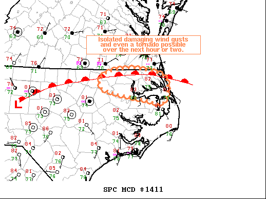
Areas affected...Far Northeastern NC
Concerning...Severe potential...Watch unlikely
Valid 011454Z - 011630Z
Probability of Watch Issuance...20 percent
SUMMARY...Isolated damaging wind gusts and even a tornado are
possible across far northeastern NC for the next hour or two.
DISCUSSION...Recent surface analysis places a low over central NC,
with a warm front extending northeastward to near the far eastern
NC/VA. This warm front is demarcated well by the 80 deg F isotherm.
The thunderstorms ongoing along the eastern NC/VA border are
occurring near this boundary, which should augment both mesoscale
lift and surface vorticity. Recent updraft intensification as well
as increased updraft rotation suggests this augmentation is
occurring now. As a result, a localized threat for damaging wind
gusts and even a brief tornado exists within this confined area of
far northeast NC. The threat will likely last for the next hour or
two, but the overall threat coverage is expected to remain too
isolated for watch issuance.
..Mosier/Grams.. 08/01/2021
...Please see www.spc.noaa.gov for graphic product...
ATTN...WFO...AKQ...MHX...RAH...
LAT...LON 36587684 36497608 36317579 35827590 35917643 36027715
36177760 36447751 36587684
|
|
Top/All Mesoscale Discussions/Forecast Products/Home
|
|


 @NWSSPC