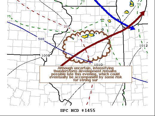
   Mesoscale Discussion 1455
   NWS Storm Prediction Center Norman OK
   0833 PM CDT Mon Aug 09 2021

   Areas affected...Parts of north central Illinois

   Concerning...Tornado Watch 417...

   Valid 100133Z - 100300Z

   The severe weather threat for Tornado Watch 417 continues.

   SUMMARY...The risk for tornadoes has diminished considerably.
   Continuing severe weather potential remains more unclear, but there
   still appears at least some potential for intensifying thunderstorm
   development and the formation of a cluster of storms to the north of
   Peoria into the 9-11 PM CDT time frame.  This could eventually pose
   increasing potential for strong wind gusts, but it remains unclear
   whether a new severe weather watch will be needed.

   DISCUSSION...A lower/mid-level low over eastern Wisconsin is
   forecast to continue to slowly migrate northeastward this evening,
   into a more stable environment across the Great Lakes region.
   However, on the southwestern flank of the mid-level troughing,
   low-level warm advection will persist through this evening across
   north central Illinois, where the boundary-layer remains very moist
   and characterized by large CAPE in excess of 3000-4000 J/kg.

   Strong thunderstorm development is ongoing along a low-level
   confluence zone north of Peoria, with perhaps some continuing
   increase in coverage underway.  This appears to be occurring in the
   presence of at least modest deep-layer shear, beneath 30 kt
   northwesterly flow around 500 mb.  This is contributing to a
   southward propagation of activity, and moderate southerly inflow of
   the potentially strongly buoyant low-level air.  At the same time,
   however, warmer and more strongly capping elevated mixed layer air
   is in the process of advecting eastward into the region, and could
   suppress convective development.

   So, subsequent convective developments remain uncertain, and
   probably hinge of the strength of the surface cold pool ongoing
   storms are able to generate in the next hour or two.  If a
   developing cold pool is able to maintain convective development,
   there appears potential for an upscale growing, southward
   propagating cluster that could pose increasing potential for strong
   surface gusts.

   ..Kerr.. 08/10/2021

   ...Please see www.spc.noaa.gov for graphic product...

   ATTN...WFO...LOT...ILX...DVN...

   LAT...LON   41209038 41478950 41478898 41368844 40738836 40448963
               40659037 41209038
|


 @NWSSPC