|
| Mesoscale Discussion 1477 |
|
< Previous MD Next MD >
|
|
Mesoscale Discussion 1477
NWS Storm Prediction Center Norman OK
1050 AM CDT Wed Aug 11 2021
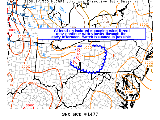
Areas affected...Portions of far eastern OH...the extreme northern
WV Panhandle...and western/central PA
Concerning...Severe potential...Watch possible
Valid 111550Z - 111745Z
Probability of Watch Issuance...40 percent
SUMMARY...At least an isolated damaging wind threat may continue
with storms through the early afternoon. Watch issuance is possible.
DISCUSSION...A small cluster of storms with a history of producing
near-severe wind gusts is presently moving eastward across far
eastern OH late this morning. Although some weak convective
inhibition remains in the boundary layer per recent mesoanalysis
estimates, continued diurnal heating should erode this inhibition
within the next couple of hours. A rather moist low-level airmass is
present downstream of the ongoing convection, with with surface
dewpoints generally in the low to mid 70s. Although the low-level
winds across western PA are not overly strong per KPBZ VWPs, there
is some increase to around 30-35 kt of westerly flow around 6 km
AGL. This may be enough to support continued modest storm
organization. Steepening low-level lapses promoting efficient
downward momentum transfer and a linear mode both suggest that at
least isolated damaging wind gusts should be the main threat with
this activity through the early afternoon. Depending on convective
intensity trends over the next hour or two, Severe Thunderstorm
Watch issuance is possible.
..Gleason/Thompson.. 08/11/2021
...Please see www.spc.noaa.gov for graphic product...
ATTN...WFO...CTP...PBZ...CLE...
LAT...LON 40468143 40758088 41588079 41597871 41317812 40307843
39827891 39777962 40158096 40468143
|
|
Top/All Mesoscale Discussions/Forecast Products/Home
|
|


 @NWSSPC