|
| Mesoscale Discussion 79 |
|
< Previous MD Next MD >
|
|
Mesoscale Discussion 0079
NWS Storm Prediction Center Norman OK
0224 PM CST Sun Jan 16 2022
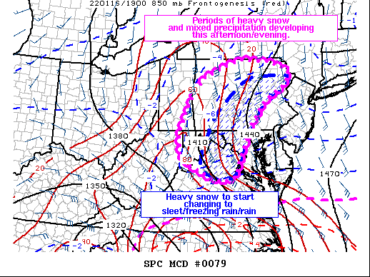
Areas affected...Portions of the central Appalachians and southern
Mid Atlantic.
Concerning...Winter mixed precipitation
Valid 162024Z - 170130Z
SUMMARY...Heavy winter precipitation is expected to increase in
coverage and intensity across portions of WV/VA into MD and PA over
the next several hours. Periodic snow rates of 1 to 1.5 inches/hour
will be possible within the heaviest bands. A change over to mixed
precipitation types including sleet and freezing rain will likely
occur, supporting ice accumulations as well.
DISCUSSION...2000 UTC surface observations fixed a 999 mb surface
low along the NC/SC border. To the north, a broad band of precip has
brought numerous reports of moderate to heavy snow across the
Carolinas and southern VA over the past several hours. Regional
water vapor/infrared imagery has shown a gradual expansion and
northward shift of cooler cloud tops associated with the
precipitation. This shift is coincident with the arrival of stronger
height falls aloft from an approaching upper low suggesting large
scale ascent is moving north. As the upper low continues to mature
and move toward the northeast, the surface low should deepen,
enhancing precipitation rates farther north into the Mid Atlantic
and central Appalachians.
Regional model sounding show cool and dry profiles that may take
some time to saturate ahead of the initial precipitation.
Evaporative and dynamic cooling should work to keep the profile cold
for several hours ahead of increasing mid-level warm advection from
the approaching low. The strong isentropic ascent will likely
support snowfall rates of 1 to 1.5 inches per hour. Quick
accumulation of snow along with poor visibility appear likely to
develop from northwest VA, through MD, and into central PA.
However, after dark, very strong warm advection will begin to peak
as several hours of warming enhance the mid-level warm nose despite
cold surface temperatures. A rapid transition to mixed precipitation
types and freezing rain is expected after 00z from southeast to
northwest. A full change over to rain may also occur farther east,
where mixing from the moderate to heavy precipitation, coupled with
strong warm advection is likely to raise surface temperatures
several degrees above freezing.
Considerable uncertainty exists along the transition zone in regard
to precipitation type and snow accumulations/rates. While most of
the area will see at least brief heavy snow before transitioning,
mixed p-types and the potential for freezing rain may support up to
a tenth of an inch of ice accumulations.
..Lyons/Grams.. 01/16/2022
...Please see www.spc.noaa.gov for graphic product...
ATTN...WFO...PHI...BGM...CTP...LWX...PBZ...RLX...
LAT...LON 38637916 38917956 39647962 40707913 41377862 41977709
41887583 41617510 41447497 41137521 40567615 39927666
38787718 38297733 38137780 38227827 38377862 38637916
|
|
Top/All Mesoscale Discussions/Forecast Products/Home
|
|


 @NWSSPC