|
| Mesoscale Discussion 98 |
|
< Previous MD Next MD >
|
|
Mesoscale Discussion 0098
NWS Storm Prediction Center Norman OK
0945 AM CST Sat Jan 29 2022
Areas affected...much of Maine
Concerning...Blizzard
Valid 291545Z - 292145Z
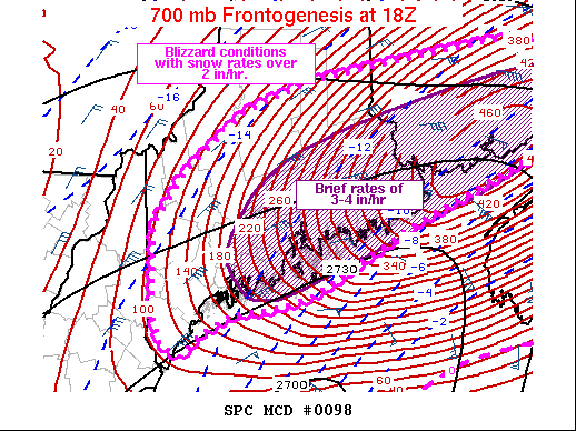
SUMMARY...Heavy blowing snow with rates of 2-3 in/hr is expected to
develop across much of coastal and Downeast Maine through midday,
and farther into the higher terrain later today.
DISCUSSION...A rapidly deepening surface low will move northeastward
toward Nova Scotia today, with intensifying large-scale lift north
of the low across Maine and New Brunswick. Strengthening
frontogenesis through a deep layer will lead to increasing snow
rates with banding currently extending from Boston toward coastal
Maine. As ascent increases within the favorable dendritic growth
zone aloft, snow rates at or above 2 in/hr should be widespread, and
3-4 in/hr may briefly occur as boundary layer temperatures range
from the single digits well inland to teens near the coast.
Forecast RAP soundings also indicate maximum boundary layer wind
speeds above 40 kt, suggesting gusts of the same within the heavier
precipitation bands.
..Jewell.. 01/29/2022
...Please see www.spc.noaa.gov for graphic product...
ATTN...WFO...CAR...GYX...
LAT...LON 43217050 43317076 43607088 44537091 45097047 45716964
46036866 46296694 46406593 46366499 46096464 45806455
45536475 45276518 45246534 44546721 43856860 43746902
43636981 43447023 43217050
|
|
Top/All Mesoscale Discussions/Forecast Products/Home
|
|


 @NWSSPC