|
| Mesoscale Discussion 115 |
|
< Previous MD Next MD >
|
|
Mesoscale Discussion 0115
NWS Storm Prediction Center Norman OK
1153 PM CST Wed Feb 02 2022
Areas affected...portions of central into northern Texas...southeast
Oklahoma...western into central Arkansas
Concerning...Winter mixed precipitation
Valid 030553Z - 031200Z
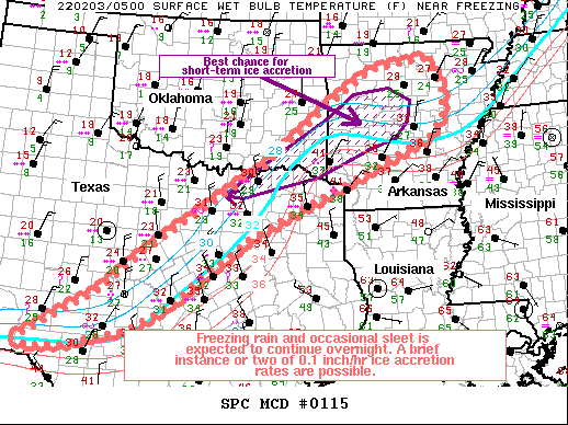
SUMMARY...Freezing rain with a transition to a wintry mix is
expected across portions of central and northern Texas towards
Arkansas over the next few hours. The best chance for ice accretions
will be from northeast Texas into western and central Arkansas.
DISCUSSION...A deep-layer moisture plume continues to overspread the
southern Plains into the Ozark Valley, and is gradually tracking
eastward with time in tandem with a broader mid-level trough. A
broad southwest-northeast oriented precipitation swath has promoted
a mix of freezing rain and occasionally sleet across southwest to
northeast TX into AR over the past few hours per surface
observations. The surface freezing line remains in place roughly
from Val Verde to Lamar County TX up to Pope County, AR. The best
chance for 0.05-0.10 inch/hr ice accretion rates continues to be
just north-northeast of the DFW metroplex into central AR, where
surface temperatures have been below freezing the longest, and where
enough warm-air advection in the 850-700 mb layer will support
rainfall, before cooler low-level temperatures usher in and support
more of a freezing rain/sleet mix. Latest high-resolution guidance,
including the 00Z HREF and last few runs of the HRRR suggest mainly
freezing rain and sleet will envelop the DFW metro into central AR
within the next couple of hours and last through at least 12Z.
..Squitieri.. 02/03/2022
...Please see www.spc.noaa.gov for graphic product...
ATTN...WFO...LZK...SHV...TSA...FWD...OUN...EWX...SJT...MAF...
LAT...LON 30060184 31219990 32059894 33959597 35289434 35949328
36149190 35579147 34989148 34549181 33849340 33169491
32489627 31559756 30959828 30449925 30100057 29970136
30060184
|
|
Top/All Mesoscale Discussions/Forecast Products/Home
|
|


 @NWSSPC