|
| Mesoscale Discussion 154 |
|
< Previous MD Next MD >
|
|
Mesoscale Discussion 0154
NWS Storm Prediction Center Norman OK
0456 AM CST Sat Feb 19 2022
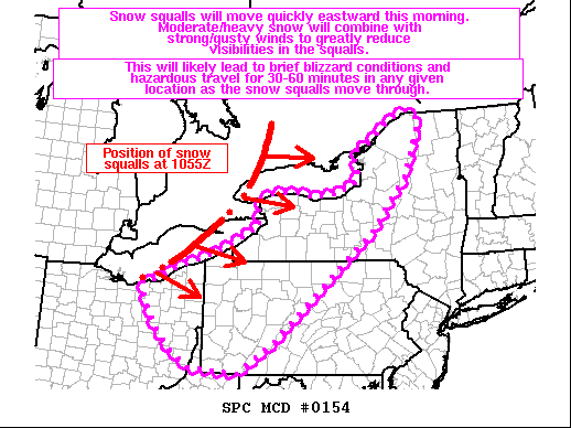
Areas affected...Portions of eastern OH...the northern WV
Panhandle...western/central PA...and western/central NY
Concerning...Snow Squall
Valid 191056Z - 191600Z
SUMMARY...Snow squalls will move quickly eastward this morning.
Moderate to heavy snow will combine with strong/gusty winds to
greatly reduce visibilities within the squalls. This will likely
lead to brief blizzard conditions and hazardous travel for 30-60
minutes in any given location as the snow squalls move through.
DISCUSSION...10Z surface analysis shows an arctic front extending
southward from a surface low from southern Ontario to Lake Erie and
northern OH. Strong low-level convergence along the front and
pronounced ascent associated with a 90-100+ kt mid-level jet streak
have encouraged the renewed development of a low-topped, broken band
of convective snow that is generally collocated with the arctic
front. Recent radar reflectivity loops from KCLE/KBUF indicate these
snow squalls are moving quickly eastward around 35-40 kt.
Current expectations are for the cold front and accompanying snow
squalls to begin impacting parts of northeastern OH, northwestern
PA, and western NY over the next couple of hours (through 13Z/8 AM
EST), and continuing eastward across more of western/central PA and
western/central NY through 16Z/11 AM EST. Low-level frontogenesis,
steepening low-level lapse rates, and the forcing of the front
itself should support a brief period (30-60 minutes) of moderate to
heavy snow as the squalls move through any given location. Strong
winds will also accompany the frontal passage, with frequent gusts
of 25-40 mph being observed in southern Ontario. These gusts will
likely lead to rapid reductions in visibility as the moderate to
heavy snow occurs within the snow squalls, resulting in brief
blizzard conditions and rather hazardous travel through much of the
morning commute.
..Gleason.. 02/19/2022
...Please see www.spc.noaa.gov for graphic product...
ATTN...WFO...BTV...ALY...BGM...BUF...CTP...PBZ...CLE...
LAT...LON 39747955 39828084 40178134 40558171 41158207 41508215
41528169 41788136 41998062 42188010 42467950 42707903
43257907 43367872 43427808 43307759 43347718 43377684
43587636 43837625 44037635 44217636 44447587 44937524
45057484 44977460 44807455 44517462 43657500 42607592
41197766 40397860 39747955
|
|
Top/All Mesoscale Discussions/Forecast Products/Home
|
|


 @NWSSPC