|
| Mesoscale Discussion 183 |
|
< Previous MD Next MD >
|
|
Mesoscale Discussion 0183
NWS Storm Prediction Center Norman OK
0921 AM CST Thu Feb 24 2022
Areas affected...Southern MO...Far Northern AR
Concerning...Winter mixed precipitation
Valid 241521Z - 241915Z
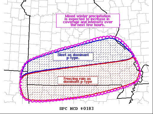
SUMMARY...Mixed winter precipitation is expected to increase in
coverage and intensity across southern Missouri and far northern
Arkansas over the next few hours.
DISCUSSION...A low-level jet currently stretches across eastern
portions of the southern Plains into the Ozark Plateau. This
low-level jet is expected to remain largely in place over the next
few hours while a shortwave trough moves through the southern High
Plains. Strong warm-air advection is ongoing within this low-level
jet, contributing to precipitation from northeast TX into central
MO. This precipitation is developing atop a wedge of cold air, with
temperatures ranging from the mid 20s from eastern OK northeastward
across southern MO into southern IL. Temperatures trend colder with
northward extent, with surface observations indicating upper teens
across west-central and central MO. Additionally, some modest
buoyancy has been noted within forecast soundings and confirmed by
the presence of deeper convection and lightning across northeast OK.
Expectation is for precipitation coverage to increase across
southern MO over the next few hours. Thermodynamic profiles appear
most supportive of freezing rain roughly south of a line from Newton
County MO northeastward to Cape Girardeau County MO. Sleet appears
more likely north of this line. Upstream radar reflectivity shows
numerous intense cells capable of high precipitation rates. Buoyancy
downstream across southern MO will remain supportive of these higher
rates for the next few hours. Given recent radar trends, potential
exists for a corridor of significant ice accumulations across far
southern MO and far northern AR.
..Mosier/Hart.. 02/24/2022
...Please see www.spc.noaa.gov for graphic product...
ATTN...WFO...PAH...MEG...LSX...LZK...SGF...TSA...
LAT...LON 37309466 37659378 37989248 38289032 36828930 36269087
36029270 35949459 36729488 37309466
|
|
Top/All Mesoscale Discussions/Forecast Products/Home
|
|


 @NWSSPC