|
| Mesoscale Discussion 194 |
|
< Previous MD Next MD >
|
|
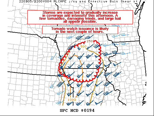
   Mesoscale Discussion 0194
   NWS Storm Prediction Center Norman OK
   0120 PM CST Sat Mar 05 2022

   Areas affected...Portions of extreme southeastern NE...much of
   southern/central IA...and northern MO

   Concerning...Severe potential...Tornado Watch likely

   Valid 051920Z - 052145Z

   Probability of Watch Issuance...80 percent

   SUMMARY...Storms are expected to gradually increase in coverage and
   intensity this afternoon. A few tornadoes, damaging winds, and large
   hail all appear possible. Watch issuance is likely in the next
   couple of hours.

   DISCUSSION...An area of precipitation with embedded storms is
   ongoing early this afternoon across parts of western/central IA and
   vicinity. This activity is being aided by strong low-level warm and
   moist advection occurring with a 40-50+ kt south-southwesterly
   low-level jet. As pronounced ascent associated with a shortwave
   trough ejecting across the central Plains overspreads the warm
   sector across IA and northern MO, additional convection is forecast
   to develop over the next couple of hours. The airmass across this
   region is gradually destabilizing, with surface temperatures
   generally in the mid 50s to upper 60s, and dewpoints in the low to
   mid 50s. Around 500-1000 J/kg of MLCAPE may ultimately develop as
   modest diurnal heating through cloud breaks occurs, as mid-level
   temperatures are expected to rapidly cool with the approach of the
   shortwave trough. Deep-layer shear of 50+ kt will favor supercells
   with a threat for both large hail and damaging winds.

   There is still some uncertainty in the coverage and intensity of
   severe storms later this afternoon owing to the modest instability
   and leading band of ongoing storms, which may hamper additional
   diurnal heating. Potential does exist for this leading band to
   strengthen as it moves across central/eastern IA while posing a
   threat for mainly hail and strong/gusty winds. Current expectations
   are for a greater severe threat to develop with supercells that
   should form near the NE/IA/MO border, in close proximity to the
   surface low over northeastern KS. This activity should have access
   to slightly greater instability and low-level moisture, with a
   better chance for these storms to become surface based and produce
   isolated large hail. Strong low-level wind fields and 200-300 m2/s2
   of effective SRH should prove favorable for updraft rotation, and a
   few tornadoes appear possible with any storms that can remain at
   least semi-discrete. Scattered damaging winds should also occur as
   convection attempts to grow upscale later this afternoon/early
   evening while moving quickly eastward across IA and northern MO. A
   watch will likely be needed within the next couple of hours as the
   severe threat gradually increases.

   ..Gleason/Hart.. 03/05/2022

   ...Please see www.spc.noaa.gov for graphic product...

   ATTN...WFO...DVN...DMX...EAX...OAX...

   LAT...LON   40309584 40699603 41129578 42109484 42439387 42669275
               42499223 42279206 40969210 40309237 39759285 39729402
               39859470 40089536 40309584
|
|
Top/All Mesoscale Discussions/Forecast Products/Home
|
|


 @NWSSPC