|
| Mesoscale Discussion 216 |
|
< Previous MD Next MD >
|
|
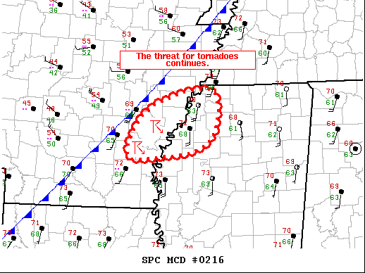
   Mesoscale Discussion 0216
   NWS Storm Prediction Center Norman OK
   0234 AM CST Mon Mar 07 2022

   Areas affected...Southeast AR...Far Northwest MS

   Concerning...Tornado Watch 35...

   Valid 070834Z - 071000Z

   The severe weather threat for Tornado Watch 35 continues.

   SUMMARY...The threat for tornadoes continues across
   southeast/east-central AR into far northwest MS.

   DISCUSSION...A pair of supercells continue to move northeastward
   across southeast AR. Current estimated storm motion is 42 kt,
   bringing both of these supercells to the AR/MS border around 09Z.
   Southerly surface winds downstream of these storms have strengthened
   over the last hour or so, with numerous observations now reporting
   sustained winds of 20 kt. Strong low-level flow also continues
   across the region, with the KNQA VAD recently sampling 65 kt at 1 km
   AGL. The KNQA VAD also shows a very large low-level hodograph, with
   the 0-1 km storm-relative helicity recently measuring over 550
   m2/s2. The downstream environment is not overly buoyant, but still
   sufficient for storm maintenance, particularly given that moisture
   advection continues. The dewpoint at CKM recently increased from 66
   deg F to 68 deg F.

   While the approaching cold front and/or additional storm development
   may begin to disrupt these supercells, the downstream environment
   currently supports storm persistence with a continued threat for
   tornadoes.

   ..Mosier.. 03/07/2022

   ...Please see www.spc.noaa.gov for graphic product...

   ATTN...WFO...MEG...JAN...LZK...

   LAT...LON   34269160 34699114 34919009 34229004 33939043 33869096
               33829168 34269160
|
|
Top/All Mesoscale Discussions/Forecast Products/Home
|
|


 @NWSSPC