|
| Mesoscale Discussion 232 |
|
< Previous MD Next MD >
|
|
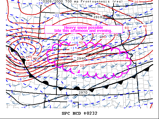
   Mesoscale Discussion 0232
   NWS Storm Prediction Center Norman OK
   0342 PM CST Wed Mar 09 2022

   Areas affected...portions of the central Plains

   Concerning...Heavy snow

   Valid 092142Z - 100345Z

   SUMMARY...Heavy snow may develop over the next few hours in
   proximity to a sagging arctic front across the central Plains. Snow
   rates of 1+ inch per hour will be possible, potentially impacting
   travel.

   DISCUSSION...As of 2140z, regional radar imagery showed a band of
   snow showers developing across portions of the central Plains.
   Driven by increasing forcing for ascent ahead of a positive-tilt
   shortwave trough over the Great Basin and central Rockies,
   precipitation coverage/intensity is forecast to increase over the
   next few hours. Aloft, strong warm advection is forecast to increase
   late this afternoon and overnight as the low-level jet increase
   across the Plains in response to the approaching trough. This along
   with strengthening frontogenesis and some symmetric instability
   release will likely support a narrow band, or bands, of moderate to
   heavy snow through parts of eastern CO and the NE/KS border region.
   Hi-res ensemble guidance agrees and suggests fairly high
   probabilities of 1 to 2 inch per hour snow rates developing within
   some of these convectively augmented bands this evening and
   overnight. While most model guidance suggests the greatest potential
   for heavy snow will occur after 02z, current radar trends suggests
   some moderate to heavy snow may develop slightly earlier closer to
   23-00z. Heavy snow will likely result in quick accumulations and
   travel problems, especially under the stronger bands later tonight.

   ..Lyons.. 03/09/2022

   ...Please see www.spc.noaa.gov for graphic product...

   ATTN...WFO...EAX...OAX...TOP...ICT...GID...LBF...DDC...GLD...
   BOU...

   LAT...LON   40209687 39859568 39529533 38999543 38599586 38489773
               38890064 39600284 39780299 39980292 40220254 40570167
               40650027 40599932 40499841 40379749 40209687
|
|
Top/All Mesoscale Discussions/Forecast Products/Home
|
|


 @NWSSPC