|
| Mesoscale Discussion 290 |
|
< Previous MD Next MD >
|
|
Mesoscale Discussion 0290
NWS Storm Prediction Center Norman OK
1157 AM CDT Mon Mar 21 2022
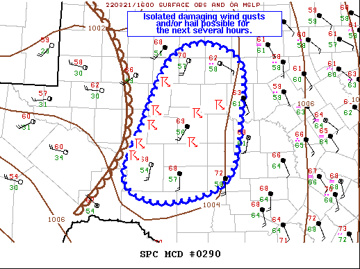
Areas affected...Southwest TX...TX Big Country
Concerning...Severe potential...Watch unlikely
Valid 211657Z - 211900Z
Probability of Watch Issuance...20 percent
SUMMARY...Isolated damaging wind gusts and/or hail are possible
across southwest TX and the TX Big Country for the next several
hours.
DISCUSSION...Temperatures have warmed into the upper 60s/lows 70s
within the clearly west of the warm conveyor but east of the main
shortwave trough. Agitated cumulus developed quickly within this
area of clearly over the past half hour, indicative of the limited
convective inhibition and at least modest forcing for ascent.
Low-level flow in this region is a bit weaker and less backed than
areas farther east, while the southerly mid-level is stronger. This
results in a more southerly deep shear vector, with a
dryline-parallel orientation. This structure to the wind fields
suggests a more linear storm structure, somewhat limiting the
overall severe potential. Even so, a few damaging wind gusts and/or
isolated instances of hail are still possible over the next few
hours, and convective trends will be monitored closely. Greater
severe potential is anticipated later this afternoon northeast/east
into more of northwest and north-central/central TX.
..Mosier.. 03/21/2022
...Please see www.spc.noaa.gov for graphic product...
ATTN...WFO...EWX...SJT...MAF...
LAT...LON 31400135 32430085 32740020 32449948 31659946 30489976
30120093 30440168 31400135
|
|
Top/All Mesoscale Discussions/Forecast Products/Home
|
|


 @NWSSPC