|
| Mesoscale Discussion 340 |
|
< Previous MD Next MD >
|
|
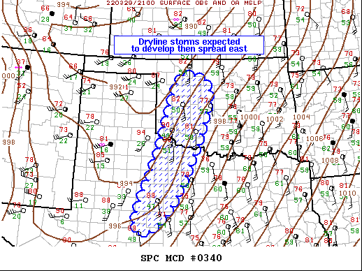
   Mesoscale Discussion 0340
   NWS Storm Prediction Center Norman OK
   0451 PM CDT Tue Mar 29 2022

   Areas affected...Western Oklahoma...Northwest/West-Central Texas

   Concerning...Severe potential...Severe Thunderstorm Watch likely

   Valid 292151Z - 292315Z

   Probability of Watch Issuance...95 percent

   SUMMARY...Scattered strong/severe thunderstorms are expected to
   initiate along the dryline. Wind/hail are the primary concerns.

   DISCUSSION...Strong boundary-layer heating has contributed to
   near-dry adiabatic lapse rate in the lowest 4km across west TX into
   western OK where surface temperatures have soared into the lower
   90s. Thickening cu field is currently noted along the eastern edge
   of this steep lapse-rate plume trailing to near I-20 north of BPG.
   Showers are gradually increasing across western OK and 700mb cooling
   is expected to remove remaining inhibition for deep, robust
   convection. Latest thinking is scattered strong/severe thunderstorms
   will develop along the dryline over the next few hours, initially
   high-based, but with time potentially becoming near-surface based as
   convection encounters increasingly moist low levels (~60F surface
   dew points). Strong mid-level height falls/forcing will contribute
   to an upward-evolving, broken squall line that will advance toward
   the I-35 corridor across OK late this evening, a bit later in
   north-central TX. Locally damaging winds and perhaps some hail are
   the primary concern.

   ..Darrow/Guyer.. 03/29/2022

   ...Please see www.spc.noaa.gov for graphic product...

   ATTN...WFO...FWD...OUN...SJT...LUB...

   LAT...LON   31709981 31610068 33949986 35659935 36479892 35959786
               33309876 31709981
|
|
Top/All Mesoscale Discussions/Forecast Products/Home
|
|


 @NWSSPC