|
| Mesoscale Discussion 357 |
|
< Previous MD Next MD >
|
|
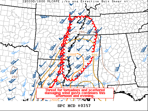
   Mesoscale Discussion 0357
   NWS Storm Prediction Center Norman OK
   0216 PM CDT Wed Mar 30 2022

   Areas affected...Central Mississippi into western Tennessee

   Concerning...Tornado Watch 77...

   Valid 301916Z - 302115Z

   The severe weather threat for Tornado Watch 77 continues.

   SUMMARY...Scattered damaging wind gusts and QLCS tornadoes will
   remain a threat this afternoon and evening.

   DISCUSSION...The most intense part of the eastward moving squall
   line is within east-central to northeast Louisiana nearing the
   Mississippi River. This line has exhibited several embedded
   circulations on the KPOE radar as it moved through central Louisiana
   over the last two hours. Downstream low-level shear remains quite
   strong per regional VWP data -- 850 mb winds are around 50 kts from
   Jackson, MS to Memphis, TN. Damaging wind gusts will continue to be
   a threat as this line moves into temperatures in the upper 70s/low
   80s F and dewpoints in the low/mid 60s F across much of
   southern/central Mississippi. Farther north into northeastern
   Arkansas and western Tennessee, buoyancy is less owing to cloud
   cover; however, low/mid-level winds remain strong. A 50 kt gust was
   observed at Stuttgart, AR despite a weaker thermodynamic
   environment.

   Tornadoes will also remain a concern given the large magnitudes of
   low level SRH -- per VWP data and objective mesoanalysis. The
   primary uncertainty is in regard to discrete storm development ahead
   of the squall line, which would pose greater risk of a strong
   tornado. The 18Z JAN sounding along with a 17Z research sounding
   near West Point, MS show mid-level temperature inversions that
   reduce buoyancy. Visible satellite trends in cumulus development
   match with the observed soundings in that updrafts have tended to
   struggle away from the main band of forcing.

   ..Wendt.. 03/30/2022

   ...Please see www.spc.noaa.gov for graphic product...

   ATTN...WFO...PAH...MEG...JAN...LZK...

   LAT...LON   31589052 31499091 31599134 32029161 34059154 35309104
               36169085 36399052 36448924 36288916 36298909 35288854
               33038907 32149002 31589052
|
|
Top/All Mesoscale Discussions/Forecast Products/Home
|
|


 @NWSSPC