|
| Mesoscale Discussion 386 |
|
< Previous MD Next MD >
|
|
Mesoscale Discussion 0386
NWS Storm Prediction Center Norman OK
0938 AM CDT Sat Apr 02 2022
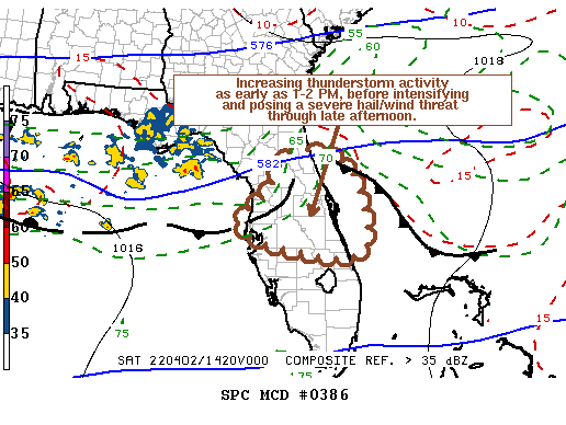
Areas affected...Parts of the central and northern Florida Peninsula
Concerning...Severe potential...Watch possible
Valid 021438Z - 021745Z
Probability of Watch Issuance...60 percent
SUMMARY...Thunderstorms may begin initiating by 1-2 PM EDT, then
pose a risk to produce severe hail and strong surface gusts through
mid to late afternoon. Trends are being monitored for the
possibility that this could require a severe weather watch.
DISCUSSION...Convection-allowing model output is rather varied
concerning potential convective evolution late this morning into mid
afternoon, beneath generally zonal mid/upper flow across much of the
Gulf of Mexico and Southeast. Low-amplitude shortwaves within one
belt of westerlies emanating from the subtropical eastern Pacific
remain out of phase with the branch of mid-level westerlies to its
north. However, models do suggest that larger-scale mid-level flow
may trend more broadly cyclonic through this afternoon, as a fairly
vigorous short wave trough progresses east-southeast of the lower
Mississippi Valley.
Colder mid-level air (including temperatures of roughly +5 to -15C
in the 700-500 mb layer) is in the process of spreading across the
northern half of the Florida Peninsula. Where surface dew points
are now near 70F, this is expected to contribute to moderately large
mixed-layer CAPE on the order of 2000+ J/kg within the next few
hours. Perhaps aided by forcing for ascent associated with
low-level warm advection, this might support increasing thunderstorm
development as early as 17-18Z.
Low-level wind fields are weak, but deep-layer shear beneath a
strong sub-tropical jet is strong, and could contribute to the
evolution of supercell structures. Some of this activity may pose a
risk for severe hail and strong wind gusts as storms intensify
through mid to late afternoon.
..Kerr/Grams.. 04/02/2022
...Please see www.spc.noaa.gov for graphic product...
ATTN...WFO...MLB...TBW...JAX...
LAT...LON 29738173 29408030 27577993 27648189 28158300 28888223
29738173
|
|
Top/All Mesoscale Discussions/Forecast Products/Home
|
|


 @NWSSPC