|
| Mesoscale Discussion 401 |
|
< Previous MD Next MD >
|
|
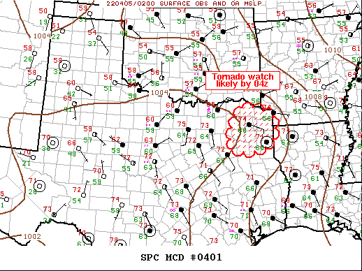
   Mesoscale Discussion 0401
   NWS Storm Prediction Center Norman OK
   1020 PM CDT Mon Apr 04 2022

   Areas affected...Northeast Texas

   Concerning...Severe potential...Watch likely

   Valid 050320Z - 050415Z

   Probability of Watch Issuance...80 percent

   SUMMARY...Tornado watch will likely be issued across the remainder
   of northeast Texas and vicinity by 04z.

   DISCUSSION...Southwest-northeast oriented MCS has evolved over
   north-central TX late this evening. While hail has been the
   predominant severe reported, the northern portion of the squall line
   near the warm front has taken more bowing characteristics. Over the
   last hour or so, this portion of the line segment has increased to
   near 40kt with KTKI reporting 43kt with this line passage. By 05z
   this activity will have progressed to the eastern edge of ww92.
   Additionally, scattered discrete updrafts continue to develop ahead
   of the squall line within the warm advection zone and these could
   evolve into supercells within a strongly sheared environment.
   Tornado watch will likely be issued by 04z to account for this
   activity shifting downstream.

   ..Darrow/Thompson.. 04/05/2022

   ...Please see www.spc.noaa.gov for graphic product...

   ATTN...WFO...SHV...FWD...

   LAT...LON   33659520 33279401 32359433 32359566 33659520
|
|
Top/All Mesoscale Discussions/Forecast Products/Home
|
|


 @NWSSPC