|
| Mesoscale Discussion 411 |
|
< Previous MD Next MD >
|
|
Mesoscale Discussion 0411
NWS Storm Prediction Center Norman OK
0150 PM CDT Tue Apr 05 2022
Areas affected...Portions of eastern GA and SC
Concerning...Severe potential...Tornado Watch likely
Valid 051850Z - 052045Z
Probability of Watch Issuance...80 percent
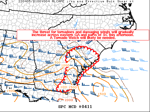
SUMMARY...The threat for tornadoes and damaging winds will gradually
increase across eastern Georgia and parts of South Carolina this
afternoon. A Tornado Watch will likely be needed.
DISCUSSION...Low-level moisture continues to increase across
coastal/eastern GA and parts of SC early this afternoon as a 40-50
kt south-southwesterly low-level jet overspreads this area. Recent
visible satellite imagery shows agitated cumulus developing across
south-central GA. Showers are also increasing across coastal SC as
the low-level warm advection strengthens, with more elevated
convection occurring into central SC closer to the surface warm
front. Supercells may develop across this region over the next
couple of hours, well ahead of the ongoing convective line now
entering western/southern GA. These leading cells will likely be
surface based, as MLCAPE of 500-1000 J/kg should be prevalent across
the warm sector. Effective SRH of 200-300+ m2/s2 and 40-50+ kt of
deep-layer shear will likely support organized updrafts and
low-level rotation with any discrete cells. A threat for tornadoes
will exist given the strong low-level shear, and damaging winds may
eventually become a threat as the line moves eastward across GA. A
strong tornado or two also appears possible with favorably enlarged
low-level hodographs and potentially discrete storm mode. A Tornado
Watch will likely be needed as observational trends dictate.
..Gleason/Mosier.. 04/05/2022
...Please see www.spc.noaa.gov for graphic product...
ATTN...WFO...ILM...CHS...CAE...JAX...
LAT...LON 31038138 30838201 30648215 30658232 30718301 31508232
31998216 32338215 32588196 32978219 33368220 33878151
34048079 33918033 33667968 33167917 32707981 32098073
31428117 31038138
|
|
Top/All Mesoscale Discussions/Forecast Products/Home
|
|


 @NWSSPC