|
| Mesoscale Discussion 474 |
|
< Previous MD Next MD >
|
|
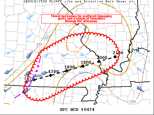
   Mesoscale Discussion 0474
   NWS Storm Prediction Center Norman OK
   1049 AM CDT Wed Apr 13 2022

   Areas affected...portions of  far northern AR...southern MO...and
   southern IL

   Concerning...Severe potential...Watch likely

   Valid 131549Z - 131645Z

   Probability of Watch Issuance...80 percent

   SUMMARY...Severe potential is increasing ahead of a developing QLCS
   across southern MO into northern AR. A watch likely will be needed
   soon downstream of this line of storms from southern MO into
   southern IL and perhaps parts of northern AR.

   DISCUSSION...A line of storms from south-central MO into far
   north-central AR has increased in intensity and organization over
   the past hour or so. While the downstream airmass continues to
   recover from overnight/morning convection and instability remains
   weak, a modest cold pool is likely aiding in better organization of
   the developing QLCS. Some additional airmass recovery downstream of
   the eastward-advancing line of storms is expected, and overall shear
   profiles will support sustained organized convection.

   Southwesterly flow increases rapidly with height across the MCD
   area, with 850 mb winds near or greater than 50 kt. If stronger cold
   pool development continues, a developing rear-inflow jet could
   increase potential for more widespread damaging gusts. While
   damaging wind potential appears to be the greater threat with this
   activity, effective SRH near 200 m2/s2 amid favorable low-level
   speed shear also will support a few mesovortex tornadoes within the
   QLCS. A watch may be needed soon for portions of the MCD area.

   ..Leitman/Thompson.. 04/13/2022

   ...Please see www.spc.noaa.gov for graphic product...

   ATTN...WFO...PAH...LSX...LZK...SGF...

   LAT...LON   36379301 37149269 37809232 38169158 38439089 38549008
               38528983 38438926 38198882 37878862 37598862 37368880
               37038953 36639073 36249165 36039217 36029261 36189296
               36379301
|
|
Top/All Mesoscale Discussions/Forecast Products/Home
|
|


 @NWSSPC