|
| Mesoscale Discussion 535 |
|
< Previous MD Next MD >
|
|
Mesoscale Discussion 0535
NWS Storm Prediction Center Norman OK
0535 PM CDT Fri Apr 22 2022
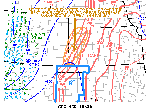
Areas affected...Far Southeast Colorado...Western Kansas
Concerning...Severe potential...Watch likely
Valid 222235Z - 230030Z
Probability of Watch Issuance...95 percent
SUMMARY...A severe threat is expected to develop over the next hour
across far southeast Colorado into western Kansas. Large hail, wind
damage and an isolated tornado threat will likely accompany the
stronger thunderstorms. Weather watch issuance will be needed soon.
DISCUSSION...Latest surface analysis has a 986 mb low over northern
Colorado with a dryline from near Goodland extending southward to
near Dalhart. To the east of the dryline, surface dewpoints are in
the mid to upper 50s F. The RAP has MLCAPE to the east of the
dryline in the 1000 to 2500 J/kg range. Thunderstorms have developed
just to the east of the dryline in the northwestern Texas Panhandle
and western Oklahoma Panhandle. This convection is expected to
continue expanding in coverage, moving north-northeastward into
southwest Kansas over the next hour. In addition to moderate
instability, RAP forecast soundings have 0-6 km shear in the 30 to
40 knot range. This combined with 700-500 mb lapse rates of 7.5 to
8.0 C/km will be favorable for supercells with large hail.
Hailstones of greater than 2 inches in diameter will be possible
with the more intense supercells.
The dryline is forecast to retreat early this evening as surface
winds back to the south-southeast. As a result, a severe threat
could impact far southeastern Colorado as well. Weather watch
issuance will likely be needed for parts of far southeast Colorado
and western Kansas needed soon.
..Broyles/Thompson.. 04/22/2022
...Please see www.spc.noaa.gov for graphic product...
ATTN...WFO...DDC...GLD...PUB...
LAT...LON 39980033 39600003 38730041 37730095 37180136 37110215
37260240 37510241 37850238 38900203 39620168 39990107
39980033
|
|
Top/All Mesoscale Discussions/Forecast Products/Home
|
|


 @NWSSPC