|
| Mesoscale Discussion 536 |
|
< Previous MD Next MD >
|
|
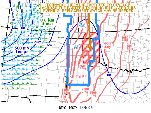
   Mesoscale Discussion 0536
   NWS Storm Prediction Center Norman OK
   0701 PM CDT Fri Apr 22 2022

   Areas affected...Eastern Oklahoma and Texas Panhandles

   Concerning...Severe Thunderstorm Watch 141...

   Valid 230001Z - 230145Z

   CORRECTED FOR WORDING

   The severe weather threat for Severe Thunderstorm Watch 141
   continues.

   SUMMARY...The severe threat will continue this evening across the
   Oklahoma and Texas Panhandle, where large hail and wind damage will
   be possible. A tornado threat could develop across the eastern Texas
   Panhandle with a couple of hours. A replacement watch could be
   necessary.

   DISCUSSION...The latest high-resolution radar imagery from Amarillo
   has several supercell thunderstorms ongoing from just northwest of
   Amarillo northward into the central Oklahoma Panhandle. These storms
   are located just to the east of a dryline, along the western edge of
   a pocket of moderate instability with MLCAPE from 2000 to 2500 J/kg.
   This combined with mid-level lapse rates of 7.5 to 8.0 C/km will be
   favorable for large hail. An isolated wind damage threat will also
   exist. Hailstones of greater than 2 inches in diameter could occur
   with the most intense updrafts.

   Over the next few hours, an 80 to 100 knot mid-level jet will
   approach the southern High Plains.  This combined with a
   strengthening low-level jet across the southern and central Plains,
   will be will markedly increase deep-layer and low-level shear. For
   these reasons, a tornado threat may develop, mainly with the most
   dominant supercells that can move eastward into the higher surface
   dewpoints across the eastern Texas Panhandle. Tornado watch issuance
   could become necessary.

   ..Broyles.. 04/23/2022

   ...Please see www.spc.noaa.gov for graphic product...

   ATTN...WFO...LUB...AMA...

   LAT...LON   36980069 36860136 36230160 35010157 34540145 34350095
               34420036 34750011 35400001 36580002 36900025 36980069
|
|
Top/All Mesoscale Discussions/Forecast Products/Home
|
|


 @NWSSPC