|
| Mesoscale Discussion 540 |
|
< Previous MD Next MD >
|
|
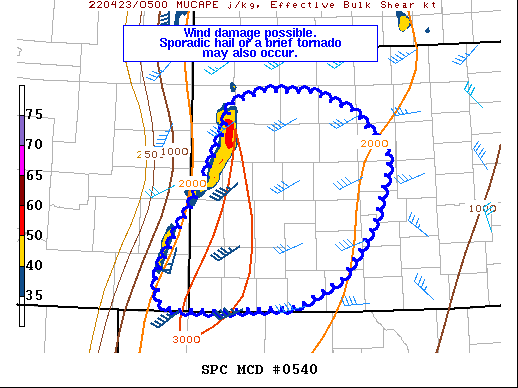
   Mesoscale Discussion 0540
   NWS Storm Prediction Center Norman OK
   1229 AM CDT Sat Apr 23 2022

   Areas affected...western Kansas

   Concerning...Severe Thunderstorm Watch 144...

   Valid 230529Z - 230730Z

   The severe weather threat for Severe Thunderstorm Watch 144
   continues.

   SUMMARY...A threat of damaging winds, sporadic hail and perhaps a
   brief tornado may persist for several more hours tonight, and a new
   watch could eventually be needed. A watch coordination is expected
   around 0545Z.

   DISCUSSION...A broken line of storms currently extends along a cold
   front from western NE into western KS and southeast CO, with the
   strongest cells across northwest KS. Despite capping, the
   substantial instability remains in place owing to steep lapse rates
   aloft and dewpoints near 60 F. In addition, very strong low-level
   convergence will continue to support new storm formation along the
   cold front.

   Tremendous low-level wind fields exist with southerly 850 mb winds
   to 90 kt and surface winds gusting above severe limits well ahead of
   the storms. Effective SRH is averaging 700-800 m2/s2 per objective
   analysis, and this should not only support damaging wind potential
   within the line but also isolated areas of QLCS potential. Should
   storms along the cold front continue to increase in coverage and
   intensity, a new watch would be needed.

   ..Jewell/Grams.. 04/23/2022

   ...Please see www.spc.noaa.gov for graphic product...

   ATTN...WFO...GID...DDC...GLD...PUB...

   LAT...LON   37379986 37070048 37020153 37020225 37120242 37390248
               37800225 38450184 38910159 39360143 39510092 39470022
               39259960 38719913 37969938 37379986
|
|
Top/All Mesoscale Discussions/Forecast Products/Home
|
|


 @NWSSPC