Mesoscale Discussion 0593
NWS Storm Prediction Center Norman OK
0109 PM CDT Sat Apr 30 2022
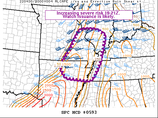
Areas affected...southeast MO...northeast AR...southern IL...far
west KY...far west TN
Concerning...Severe potential...Watch likely
Valid 301809Z - 302015Z
Probability of Watch Issuance...80 percent
SUMMARY...The risk of severe thunderstorms capable of damaging
gusts, large hail, and a couple tornadoes will increase between
19-21Z. Watch issuance is likely.
DISCUSSION...A NNE-SSW oriented cold front currently draped across
parts of central MO into west-central AR will continue shifting
slowly eastward through the afternoon. Ahead of the front, pockets
of diurnal heating will continue to reduce lingering CINH, while
dewpoints increase into the middle 60s F. This will result in around
1000-1500 J/kg MLCAPE, which combined with increasing ascent
along/ahead of the approaching cold front will support increasing
convection through the afternoon. Regional VWP data shows around
40-50 kt of midlevel southwesterly flow overspreading the area,
which will contribute to around 40 knots of effective bulk shear as
convection begins to mature in the presence of steepening low-level
lapse rates. Generally weak forcing for ascent coupled with an
oblique orientation of the deep-layer flow to the initiating
boundary could favor initially semi-discrete supercells capable of
damaging winds, large hail, and a couple tornadoes. With time,
convection should have a tendency to grow upscale into linear
segments, when damaging winds and perhaps an embedded tornado or two
will become the primary concerns. Watch issuance will likely be
needed this afternoon.
..Weinman/Hart.. 04/30/2022
...Please see www.spc.noaa.gov for graphic product...
ATTN...WFO...PAH...MEG...LSX...LZK...SGF...
LAT...LON 36369238 36749214 37259176 37739151 38639102 38869059
38828921 38378848 36318906 35338962 35058997 35279205
35929256 36369238
|


 @NWSSPC